Image:Mapa físico de la provincia de Alicante (España).png
From Wikipedia, the free encyclopedia
No higher resolution available.
Mapa_físico_de_la_provincia_de_Alicante_(España).png (504 × 443 pixels, file size: 306 KB, MIME type: image/png)
| | This is a file from the Wikimedia Commons. The description on its description page there is shown below.
|
| Description |
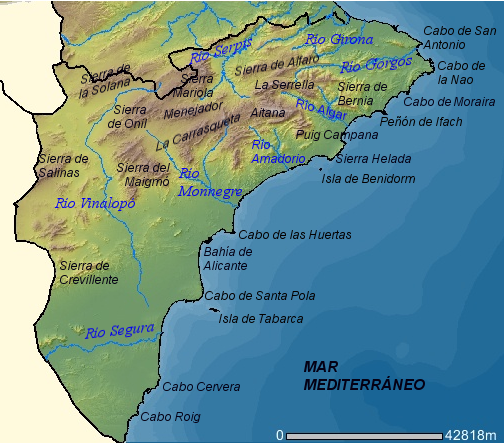
Mapa físico de la provincia de Alicante (España). |
|---|---|
| Source | |
| Date |
2007 |
| Author |
Mapa realizado por Rodriguillo a partir de una imagen del Visor de Cartografía CTH de la Comunidad Valenciana. Esta imagen puede ser reproducida bajo licencia GFDL con la autorización de la Consellería de Territori i Habitatge de la Generalidad Valenciana (es:Wikipedia:Autorizaciones/Visor de Cartografía CTH de la Comunidad Valenciana) |
| Permission (Reusing this image) |
GFDL |
| I, the copyright holder of this work, hereby release it into the public domain. This applies worldwide. In case this is not legally possible: Afrikaans | Alemannisch | Aragonés | العربية | Asturianu | Български | Català | Česky | Cymraeg | Dansk | Deutsch | Eʋegbe | Ελληνικά | English | Español | Esperanto | Euskara | Estremeñu | فارسی | Français | Galego | 한국어 | हिन्दी | Hrvatski | Ido | Bahasa Indonesia | Íslenska | Italiano | עברית | Kurdî / كوردی | Latina | Lietuvių | Latviešu | Magyar | Македонски | Bahasa Melayu | Nederlands | Norsk (bokmål) | Norsk (nynorsk) | 日本語 | Polski | Português | Ripoarisch | Română | Русский | Shqip | Slovenčina | Slovenščina | Српски / Srpski | Svenska | ไทย | Tagalog | Türkçe | Українська | Tiếng Việt | Walon | 中文(简体) | 中文(繁體) | zh-yue-hant | +/- |
File history
Click on a date/time to view the file as it appeared at that time.
| Date/Time | Dimensions | User | Comment | |
|---|---|---|---|---|
| current | 23:27, 27 April 2007 | 504×443 (306 KB) | Rodriguillo | |
| 23:10, 27 April 2007 | 504×443 (304 KB) | Rodriguillo | ({{Information |Description='''Mapa físico de la provincia de Alicante (España)'''. |Source=http://orto.cth.gva.es |Date=2007 |Author=Mapa realizado por Rodriguillo a partir de una imagen del Visor de Cartografía CTH de la C) |


.png)