Image:Mapa - Paises voseantes.png
From Wikipedia, the free encyclopedia
No higher resolution available.
Mapa_-_Paises_voseantes.png (402 × 450 pixels, file size: 36 KB, MIME type: image/png)
| | This is a file from the Wikimedia Commons. The description on its description page there is shown below.
|
[edit] Summary
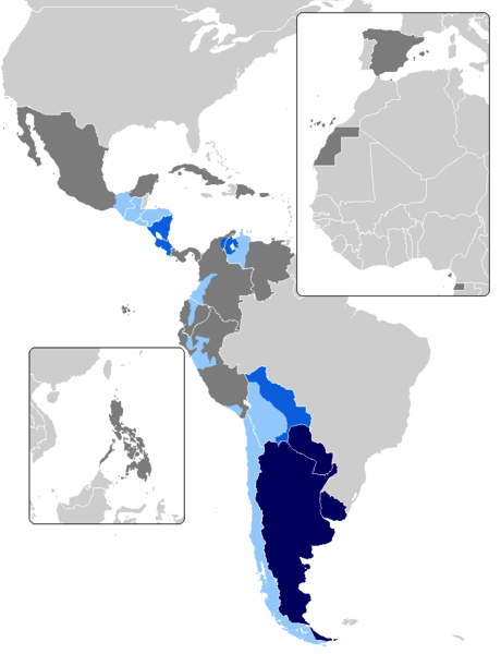
| Description |
English: Map of countries with voseo. In dark blue, countries with voseo predominance. In blue, countries where is as used as tuteo. In green, countries where it is featured as a regionalism. In sky blue, countries where is almost unused. In red, countries where only exists tuteo.
Español: Mapa del voseo en Latinoamérica. En azul oscuro, países donde predomina completamente sobre el tuteo; en azul, países donde ambas formas coexisten; en verde, países en que es un fenómeno regional; en celeste, aquellos países en que casi no se usa; y en rojo, países donde sólo hay tuteo.
|
|---|---|
| Source |
Image:Map-Latin America2.png, Image:BlankMap-World.png, Diccionario Panhispánico de Dudas y Fórmulas de tratamiento en dialectos del español |
| Date |
5-oct-2006 |
| Author |
Marcel Montes |
| Permission (Reusing this image) |
see below |
[edit] Licensing
|
File history
Click on a date/time to view the file as it appeared at that time.
| Date/Time | Dimensions | User | Comment | |
|---|---|---|---|---|
| current | 03:01, 14 June 2008 | 402×450 (36 KB) | Lin linao | |
| 19:46, 12 June 2008 | 402×450 (36 KB) | Lin linao | ({{Information |Description={{es|Mapa del voseo en Latinoamérica. En azul oscuro, países donde no se usa el tuteo, en azul, países donde voseo y tuteo coexisten, en verde, países en que el voseo existe en algunas regiones, en celeste, pa�) | |
| 20:24, 11 June 2008 | 402×450 (23 KB) | Anna | (Reverted to version as of 05:00, 6 June 2008, preferably a blank map to put the appropriate footnotes) | |
| 18:13, 9 June 2008 | 402×450 (10 KB) | El bart089 | (Reverted to version as of 01:46, 4 June 2008) | |
| 05:00, 6 June 2008 | 402×450 (23 KB) | Neutre | (Reverted to version as of 15:47, 27 May 2008) | |
| 01:46, 4 June 2008 | 402×450 (10 KB) | El bart089 | (Updated version with colour description.) | |
| 15:47, 27 May 2008 | 402×450 (23 KB) | Lin linao | ||
| 07:43, 5 October 2006 | 402×450 (23 KB) | SpiceMan | ({{Information |Description=Mapa de los países voseantes |Source=Image:Map-Latin-America2.png and Image:800px-BlankMap-World-v6.png |Date=5-oct-2006 |Author=Marcel Montes |Permission= |other_versions= }} * '''es''': Mapa de países [[:es:voseo|vo) |
File links
The following pages on the English Wikipedia link to this file (pages on other projects are not listed):

