Image:Map of UTA Flight 772.jpg
From Wikipedia, the free encyclopedia
No higher resolution available.
Map_of_UTA_Flight_772.jpg (462 × 537 pixels, file size: 241 KB, MIME type: image/jpeg)
| | This is a file from the Wikimedia Commons. The description on its description page there is shown below.
|
| Description |
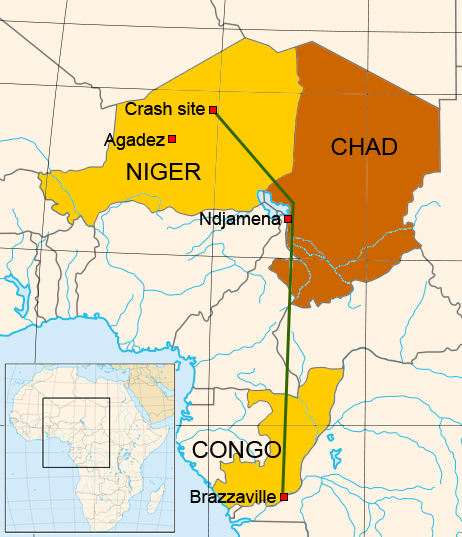
A Map of the flight of UTA Flight 772 on September 19, 1989 |
|---|---|
| Source |
Based on a BBC news map (but not traced) - Map based on Image:Africa_map_blank.svg by Eric Gaba fr:Sting |
| Date |
15 July |
| Author |
Eric Gaba and Max Smith |
| Permission (Reusing this image) |
As before GFDL or cc-by-sa-2.5,2.0,1.0 |

File history
Click on a date/time to view the file as it appeared at that time.
| Date/Time | Dimensions | User | Comment | |
|---|---|---|---|---|
| current | 08:47, 15 July 2007 | 462×537 (241 KB) | Megapixie | ({{Information |Description=A Map of the flight of UTA Flight 772 on September 19, 1989 |Source=Based on a BBC news map (but not traced) - Map based on Image:Africa_map_blank.svg by Eric Gaba fr:Sting |Date=15 July |Author=) |
File links
The following pages on the English Wikipedia link to this file (pages on other projects are not listed):
Metadata
This file contains additional information, probably added from the digital camera or scanner used to create or digitize it. If the file has been modified from its original state, some details may not fully reflect the modified file.
| Orientation | Normal |
|---|---|
| Horizontal resolution | 72 dpi |
| Vertical resolution | 72 dpi |
| Software used | Adobe Photoshop CS2 Windows |
| File change date and time | 17:43, 15 July 2007 |
| Color space | sRGB |

