Image:Map of Languages (in Districts) in Afghanistan.jpg
From Wikipedia, the free encyclopedia
Size of this preview: 794 × 600 pixels
Full resolution (1,162 × 878 pixels, file size: 777 KB, MIME type: image/jpeg)
| | This is a file from the Wikimedia Commons. The description on its description page there is shown below.
|
 |
This map image should be recreated using vector graphics as an SVG file. This has several advantages; see Commons:Media for cleanup for more information. If an SVG form of this image is already available, please upload it. After uploading an SVG, replace this template with template {{Vector version available|new image name.svg}} in this image. |
|
العربية | Български | Català | Česky | Dansk | Deutsch | English | Esperanto | Español | Français | 한국어 | Italiano | Magyar | Lietuvių | Nederlands | 日本語 | Polski | Português | Română | Русский | Suomi | Svenska | Türkçe | Українська | Tiếng Việt | मराठी | 中文(繁體) | 中文(简体) | +/- |
|
[edit] Summary
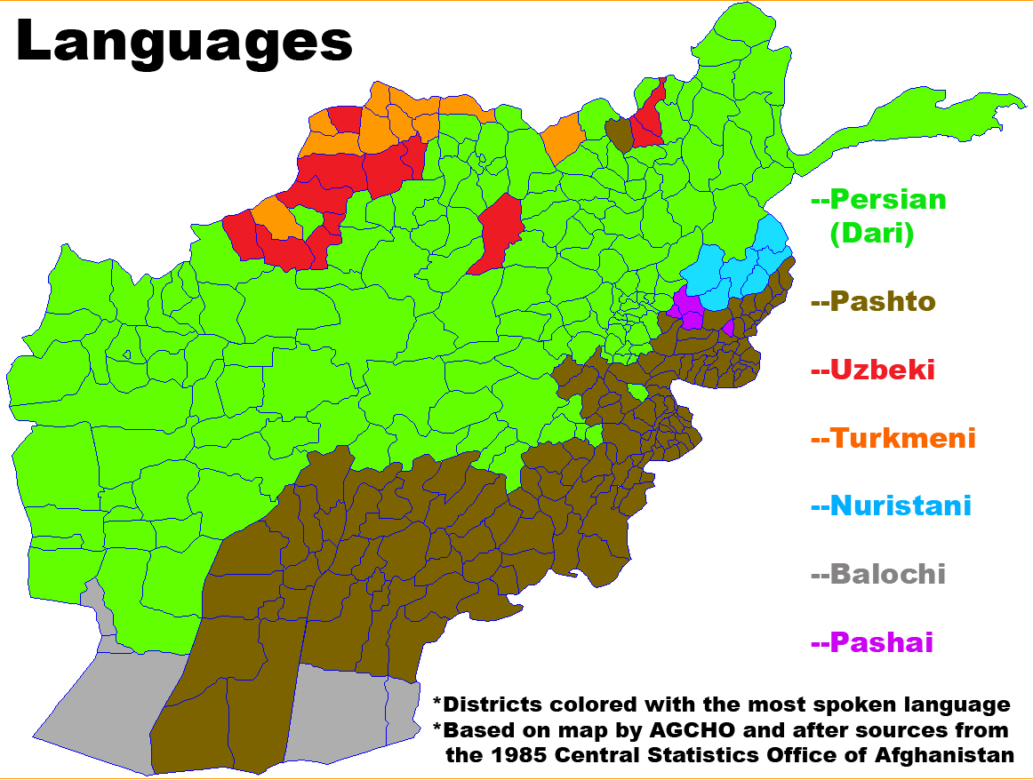
- Map showing the most spoken language in each district in Afghanistan.
- Based on ethnic data from AIMS and this map from the National Atlas of the Democratic Republic of Afghanistan (Warsaw: Geokart Organization for Surveying and Cartography, 1985, ISBN 83-00-02327-5), p. 29
- Made from this image on Commons by User:Rarelibra.
[edit] Licensing
| I, the copyright holder of this work, hereby release it into the public domain. This applies worldwide. In case this is not legally possible: Afrikaans | Alemannisch | Aragonés | العربية | Asturianu | Български | Català | Česky | Cymraeg | Dansk | Deutsch | Eʋegbe | Ελληνικά | English | Español | Esperanto | Euskara | Estremeñu | فارسی | Français | Galego | 한국어 | हिन्दी | Hrvatski | Ido | Bahasa Indonesia | Íslenska | Italiano | עברית | Kurdî / كوردی | Latina | Lietuvių | Latviešu | Magyar | Македонски | Bahasa Melayu | Nederlands | Norsk (bokmål) | Norsk (nynorsk) | 日本語 | Polski | Português | Ripoarisch | Română | Русский | Shqip | Slovenčina | Slovenščina | Српски / Srpski | Svenska | ไทย | Tagalog | Türkçe | Українська | Tiếng Việt | Walon | 中文(简体) | 中文(繁體) | zh-yue-hant | +/- |
File history
Click on a date/time to view the file as it appeared at that time.
| Date/Time | Dimensions | User | Comment | |
|---|---|---|---|---|
| current | 01:53, 22 January 2008 | 1,162×878 (777 KB) | Le Behnam | (== Summary == *Map showing the most spoken language in each district in Afghanistan. *Based on ethnic data from ''AIMS'' and [http://www.evertype.com/standards/af/lang-af.html this map from the National Atlas of the Democratic Republic of Afghanistan (Wa) |
File links
Metadata
This file contains additional information, probably added from the digital camera or scanner used to create or digitize it. If the file has been modified from its original state, some details may not fully reflect the modified file.
| Orientation | Normal |
|---|---|
| Horizontal resolution | 96.012 dpi |
| Vertical resolution | 96.012 dpi |
| Software used | Adobe Photoshop CS3 Windows |
| File change date and time | 20:47, 21 January 2008 |
| Color space | sRGB |

