Image:Map of Finland with provinces (numbered).png
From Wikipedia, the free encyclopedia
No higher resolution available.
Map_of_Finland_with_provinces_(numbered).png (150 × 260 pixels, file size: 2 KB, MIME type: image/png)
| | This is a file from the Wikimedia Commons. The description on its description page there is shown below.
|
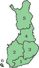
Map of Finland with the Province lines visible (numbered)
(c) adrian.benko, 2005, based on images by (c) helix84, 2005, based on images by (c) Jani Niemenmaa, 2003

File history
Click on a date/time to view the file as it appeared at that time.
| Date/Time | Dimensions | User | Comment | |
|---|---|---|---|---|
| current | 15:37, 12 October 2007 | 150×260 (2 KB) | Skies | (Map of Finland with the Province lines visible (numbered) (c) adrian.benko, 2005, based on images by (c) helix84, 2005, based on images by (c) Jani Niemenmaa, 2003 {{GFDL}} [[Category:Locator m) |
| 15:34, 12 October 2007 | 150×260 (2 KB) | Skies | (Map of Finland with the Province lines visible (numbered) (c) adrian.benko, 2005, based on images by (c) helix84, 2005, based on images by (c) Jani Niemenmaa, 2003 {{GFDL}} [[Category:Locator m) | |
| 18:32, 27 April 2005 | 150×261 (17 KB) | Adrian.benko | (Map of Finland with the Province lines visible (numbered) (c) User:adrian.benko, 2005, based on images by (c) helix84, 2005, based on images by (c) Jani Niemenmaa, 2003 {{GFDL}}) |
File links
The following pages on the English Wikipedia link to this file (pages on other projects are not listed):


.png)
.png)