Image:Map of Burgas-alexandroupoli pipeline.gif
From Wikipedia, the free encyclopedia
No higher resolution available.
Map_of_Burgas-alexandroupoli_pipeline.gif (280 × 220 pixels, file size: 9 KB, MIME type: image/gif)
| | This is a file from the Wikimedia Commons. The description on its description page there is shown below.
|
[edit] Summary
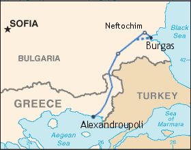
| Description |
Map of the Burgas-Alexandroupoli pipeline. |
|---|---|
| Source | |
| Date |
7 May 2006 |
| Author |
Central Intelligence Agency's World Factbook map, with additions by User:TodorBozhinov released into the public domain. |
| Permission (Reusing this image) |
see below |
[edit] Licensing
| This work is in the public domain in the United States because it is a work of the United States Federal Government under the terms of Title 17, Chapter 1, Section 105 of the US Code. See Copyright.
Note: This only applies to works of the Federal Government and not to the work of any individual U.S. state, territory, commonwealth, county, municipality, or any other subdivision. العربية | Български | Česky | Deutsch | English | Español | Français | Magyar | Italiano | 日本語 | 한국어 | Polski | Português | 中文(繁體) | 中文(简体) | +/- |
 |
File history
Click on a date/time to view the file as it appeared at that time.
| Date/Time | Dimensions | User | Comment | |
|---|---|---|---|---|
| current | 13:24, 15 March 2007 | 280×220 (9 KB) | Doldrums | ({{Information |Description=Map of the w:Burgas-Alexandroupoli pipeline. |Source=w:Image:Burgas-alexandroupoli.gif |Date=7 May 2006 |Author=Central Intelligence Agency's World Factbook map, with additions by w:User:TodorBozhinov released i) |
File links
The following file is a duplicate of this file:
No pages on the English Wikipedia link to this file. (Pages on other projects are not counted.)

