Image:Map indicating Davis Strait.png
From Wikipedia, the free encyclopedia
No higher resolution available.
Map_indicating_Davis_Strait.png (340 × 330 pixels, file size: 47 KB, MIME type: image/png)
| | This is a file from the Wikimedia Commons. The description on its description page there is shown below.
|
[edit] Summary
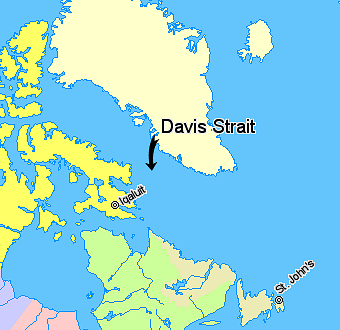
Map indicating Davis Strait, lying between Greenland and Nunavut, Canada.
██ Nunavut
██ Quebec
██ Newfoundland and Labrador
██ Regions outside Canada (Greenland, Iceland)
© Her Majesty the Queen in Right of Canada, Department of Natural Resources. All rights reserved.
Licence Agreement
[edit] Licensing
 |
The copyright holder of this work allows anyone to use it for any purpose including unrestricted redistribution, commercial use, and modification.
Note: العربية | Asturianu | Български | Česky | Dansk | Deutsch | English | Esperanto | Español | فارسی | Français | Galego | Italiano | 日本語 | 한국어 | Kurdî / كوردی | Nederlands | Polski | Português | Русский | Suomi | Svenska | Türkçe | Shqip | 中文(简体) | 中文(繁體) | 粵語 | +/- |
File history
Click on a date/time to view the file as it appeared at that time.
| Date/Time | Dimensions | User | Comment | |
|---|---|---|---|---|
| current | 11:08, 21 March 2006 | 340×330 (47 KB) | David Kernow | (Map indicating Davis Strait, lying between Nunavut, Canada and Greenland. {{legend|#ffff66|Nunavut}} {{legend|#d5fe94|Quebec}} {{legend|#ecebb6|Newfoundland and Labrador}} {{legend|#ffffcc|Regions outside Canada (Greenland, Iceland)}} ) |

