Image:Map Northern Mariana Islands closer.gif
From Wikipedia, the free encyclopedia
No higher resolution available.
Map_Northern_Mariana_Islands_closer.gif (435 × 580 pixels, file size: 34 KB, MIME type: image/gif)
| | This is a file from the Wikimedia Commons. The description on its description page there is shown below.
|
[edit] Summary
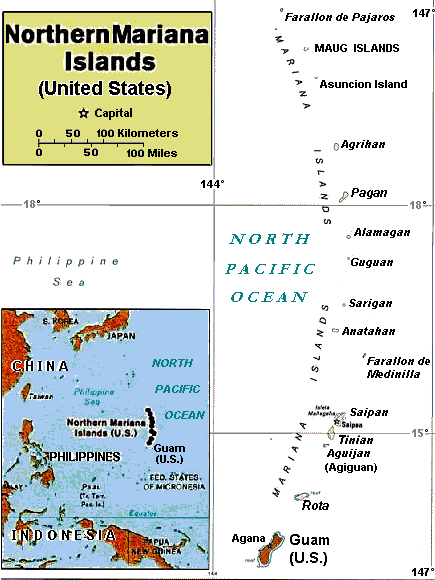
| Description |
Enlarged area map of the Northern Mariana Islands. |
|---|---|
| Source |
Derived by re-labeling and narrowing map Image:Casta Marianas.jpg from maps at http://www.lib.utexas.edu/maps/ Public Domain (see http://navalhistory.flixco.info/H/118421x19817/8330/a0.htm) |
| Date |
6 March 2008 |
| Author |
User:Wikid77, from 2005 map of User:Bradipus |
| Permission (Reusing this image) |
see below |
| Other versions | Wider map (2x wider) with tiny lettering: Image:Casta Marianas.jpg. |
[edit] Licensing
| I, the copyright holder of this work, hereby release it into the public domain. This applies worldwide. In case this is not legally possible: Afrikaans | Alemannisch | Aragonés | العربية | Asturianu | Български | Català | Česky | Cymraeg | Dansk | Deutsch | Eʋegbe | Ελληνικά | English | Español | Esperanto | Euskara | Estremeñu | فارسی | Français | Galego | 한국어 | हिन्दी | Hrvatski | Ido | Bahasa Indonesia | Íslenska | Italiano | עברית | Kurdî / كوردی | Latina | Lietuvių | Latviešu | Magyar | Македонски | Bahasa Melayu | Nederlands | Norsk (bokmål) | Norsk (nynorsk) | 日本語 | Polski | Português | Ripoarisch | Română | Русский | Shqip | Slovenčina | Slovenščina | Српски / Srpski | Svenska | ไทย | Tagalog | Türkçe | Українська | Tiếng Việt | Walon | 中文(简体) | 中文(繁體) | zh-yue-hant | +/- |
File history
Click on a date/time to view the file as it appeared at that time.
| Date/Time | Dimensions | User | Comment | |
|---|---|---|---|---|
| current | 15:52, 6 March 2008 | 435×580 (34 KB) | Wikid77 | (labeled "(Agiguan)" and clarified title-box scale, reducing data 1400b; aligned labels; clarified sea color; etc.) |
| 14:43, 6 March 2008 | 435×580 (35 KB) | Wikid77 | (initial upload) |

