Image:Map Mobile River tunnels area.gif
From Wikipedia, the free encyclopedia
No higher resolution available.
Map_Mobile_River_tunnels_area.gif (680 × 560 pixels, file size: 34 KB, MIME type: image/gif)
| | This is a file from the Wikimedia Commons. The description on its description page there is shown below.
|
[edit] Summary
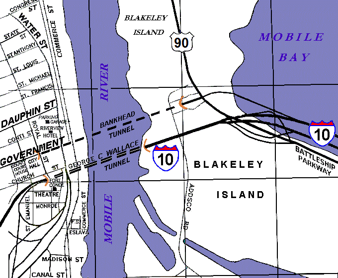
| Description |
Rough diagram of central Mobile, Alabama, along the Mobile River, showing locations of the Bankhead Tunnel and the George C. Wallace Tunnel connecting Blakeley Island to downtown Mobile. The whole area is within the Mobile city limits which begin further east, just beyond Battleship Memorial Park along the Jubilee Parkway. |
|---|---|
| Source |
self-made (based on archives map) |
| Date |
12-December-2007 |
| Author | |
| Permission (Reusing this image) |
(see below) |
[edit] Licensing
| I, the copyright holder of this work, hereby release it into the public domain. This applies worldwide. In case this is not legally possible: Afrikaans | Alemannisch | Aragonés | العربية | Asturianu | Български | Català | Česky | Cymraeg | Dansk | Deutsch | Eʋegbe | Ελληνικά | English | Español | Esperanto | Euskara | Estremeñu | فارسی | Français | Galego | 한국어 | हिन्दी | Hrvatski | Ido | Bahasa Indonesia | Íslenska | Italiano | עברית | Kurdî / كوردی | Latina | Lietuvių | Latviešu | Magyar | Македонски | Bahasa Melayu | Nederlands | Norsk (bokmål) | Norsk (nynorsk) | 日本語 | Polski | Português | Ripoarisch | Română | Русский | Shqip | Slovenčina | Slovenščina | Српски / Srpski | Svenska | ไทย | Tagalog | Türkçe | Українська | Tiếng Việt | Walon | 中文(简体) | 中文(繁體) | zh-yue-hant | +/- |
File history
Click on a date/time to view the file as it appeared at that time.
| Date/Time | Dimensions | User | Comment | |
|---|---|---|---|---|
| current | 19:36, 12 December 2007 | 680×560 (34 KB) | Wikid77 | (initial upload) |

