Image:Map Hudson County NJ municipalities.gif
From Wikipedia, the free encyclopedia
No higher resolution available.
Map_Hudson_County_NJ_municipalities.gif (430 × 599 pixels, file size: 25 KB, MIME type: image/gif)
| | This is a file from the Wikimedia Commons. The description on its description page there is shown below.
|
|
|
This image was uploaded in a format such as GIF or JPEG. It could be stored, however, in the PNG format which supports lossless compression and transparency. Because the PNG format supports lossless compression, edits made to PNG files do not reduce their quality. If possible, please upload a PNG version of this image. After doing so, please replace all instances of the previous version throughout Commons (noted under the "File links" header), and remove this tag. For more information, see Commons:Preparing images for upload. |
|
|
|
| Description |
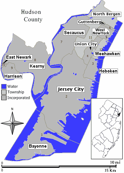
Closeup view of map of Hudson County, New Jersey (in style of map work by Jim Irwin, December 2005), with distance scale in miles/kilometers, Interstate-icons enlarged 50%, town names clarified, and side-edges limited (maximum width 430px < 600px helps readability). |
|---|---|
| Source |
Hand-edited like Wikimedia map: Image:Middletown twp nj 025.png (using gray town areas, with miles/kilometer scale, and road/icon colors). |
| Date |
21-August-2007 |
| Author | |
| Permission (Reusing this image) |
(see below) |
[edit] Licensing
|

File history
Click on a date/time to view the file as it appeared at that time.
| Date/Time | Dimensions | User | Comment | |
|---|---|---|---|---|
| current | 23:37, 21 August 2007 | 430×599 (25 KB) | Wikid77 | (added forgotten name "West New York" on area #5) |
| 23:19, 21 August 2007 | 430×599 (24 KB) | Wikid77 | (redrew entire map with detailed water-boundaries (actually more narrow 430px), with darker town names) | |
| 17:21, 21 August 2007 | 540×580 (21 KB) | Wikid77 | ({{Information | Description= Closeup view of map of Hudson County, New Jersey (in style of map work by Jim Irwin, December 2005), with distance scale in miles/kilometers, Interstate-icons enlarged 50%, town names clarifie) |

