Image:Manantali dam.jpg
From Wikipedia, the free encyclopedia
No higher resolution available.
Manantali_dam.jpg (800 × 158 pixels, file size: 28 KB, MIME type: image/jpeg)
| | This is a file from the Wikimedia Commons. The description on its description page there is shown below.
|
[edit] Summary
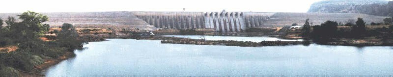
| Description |
Mali's second multi-purpose dam, Manantali Dam, is located approximately 1200 km. upstream, and was built by the OMVS on the Bafig tributary of the Senegal River in Mali. |
|---|---|
| Source |
http://www.fas.usda.gov/pecad2/highlights/2001/10/senegal/pictures/Manantali_dam.jpg "Rice Production in Senegal Sustained", United States Department of Agriculture Foreign Agricultural Service October 22, 2001 |
| Date |
2001 |
| Author |
USDA, PECAD/FAS |
| Permission (Reusing this image) |
PD |
[edit] Licensing
| This work is in the public domain in the United States because it is a work of the United States Federal Government under the terms of Title 17, Chapter 1, Section 105 of the US Code. See Copyright.
Note: This only applies to works of the Federal Government and not to the work of any individual U.S. state, territory, commonwealth, county, municipality, or any other subdivision. العربية | Български | Česky | Deutsch | English | Español | Français | Magyar | Italiano | 日本語 | 한국어 | Polski | Português | 中文(繁體) | 中文(简体) | +/- |
 |
File history
Click on a date/time to view the file as it appeared at that time.
| Date/Time | Dimensions | User | Comment | |
|---|---|---|---|---|
| current | 00:19, 7 March 2008 | 800×158 (28 KB) | T L Miles | ({{Information |Description=Mali's second multi-purpose dam, Manantali Dam, is located approximately 1200 km. upstream, and was built by the OMVS on the Bafig tributary of the Senegal River in Mali. |Source=http://www.fas.usda.gov/pecad2/highlights/2001/10) |

