Image:MalaspinaRouteMap.png
From Wikipedia, the free encyclopedia
No higher resolution available.
MalaspinaRouteMap.png (781 × 585 pixels, file size: 100 KB, MIME type: image/png)
| | This is a file from the Wikimedia Commons. The description on its description page there is shown below.
|
[edit] Summary
| Description |
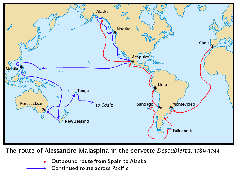
This is a map of the route taken by Alessandro Malaspina during his expedition of 1789-1794. The map shows only the route of Malaspina's ship, Descubierta. A second ship, Atrevida, under command of José Bustamante accompanied Malaspina along most but not all of this route. The return route from Tonga to Spain is not shown. I, Pfly, made this map, using various sources that describe the expedition and its route. |
|---|---|
| Source |
self-made |
| Date |
February 16, 2008 |
| Author | |
| Permission (Reusing this image) |
see below |
[edit] Licensing

File history
Click on a date/time to view the file as it appeared at that time.
| Date/Time | Dimensions | User | Comment | |
|---|---|---|---|---|
| current | 03:00, 17 February 2008 | 781×585 (100 KB) | Pfly | ({{Information |Description=This is a map of the route taken by Alessandro Malaspina during his expedition of 1789-1794. The map shows only the route of Malaspina's ship, ''Descubierta''. A second ship, ''Atrevida'', under comm) |
File links
The following pages on the English Wikipedia link to this file (pages on other projects are not listed):

