Image:Luxembourg legislative election 2004 communes map.png
From Wikipedia, the free encyclopedia
No higher resolution available.
Luxembourg_legislative_election_2004_communes_map.png (203 × 270 pixels, file size: 7 KB, MIME type: image/png)
| | This is a file from the Wikimedia Commons. The description on its description page there is shown below.
|
[edit] Summary
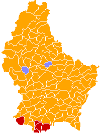
| Description |
A map of the communes of Luxembourg (prior to the mergers of 1 January 2006) coloured by the plurality party in the 2004 election to the Chamber of Deputies. Orange represents the Christian Social People's Party, red represents the Luxembourg Socialist Workers' Party, and light blue represents the Democratic Party. |
|---|---|
| Source |
Own work based on Image:Communes of Luxembourg.PNG. |
| Date |
2008-03-01 |
| Author | |
| Permission (Reusing this image) |
Released into the public domain. See licence below. |
[edit] Licensing
| I, the copyright holder of this work, hereby release it into the public domain. This applies worldwide. In case this is not legally possible: Afrikaans | Alemannisch | Aragonés | العربية | Asturianu | Български | Català | Česky | Cymraeg | Dansk | Deutsch | Eʋegbe | Ελληνικά | English | Español | Esperanto | Euskara | Estremeñu | فارسی | Français | Galego | 한국어 | हिन्दी | Hrvatski | Ido | Bahasa Indonesia | Íslenska | Italiano | עברית | Kurdî / كوردی | Latina | Lietuvių | Latviešu | Magyar | Македонски | Bahasa Melayu | Nederlands | Norsk (bokmål) | Norsk (nynorsk) | 日本語 | Polski | Português | Ripoarisch | Română | Русский | Shqip | Slovenčina | Slovenščina | Српски / Srpski | Svenska | ไทย | Tagalog | Türkçe | Українська | Tiếng Việt | Walon | 中文(简体) | 中文(繁體) | zh-yue-hant | +/- |
File history
Click on a date/time to view the file as it appeared at that time.
| Date/Time | Dimensions | User | Comment | |
|---|---|---|---|---|
| current | 21:17, 1 March 2008 | 203×270 (7 KB) | Bastin8 | ({{Information| |Description=A map of communes of Luxembourg after mergers of 2006-01-01, colour-coded by geographic area. Area is denoted by eight different shades of green; in order of increasingly darker shades, the lower bounds (in km²) are: 0, 10, 1) |

