Image:LuxembourgPartitionsMap english.jpg
From Wikipedia, the free encyclopedia
No higher resolution available.
LuxembourgPartitionsMap_english.jpg (433 × 569 pixels, file size: 82 KB, MIME type: image/jpeg)
| | This is a file from the Wikimedia Commons. The description on its description page there is shown below.
|
This image was (or all images in this article or category were) uploaded in the JPEG format.
However, it contains information that could be stored more efficiently or more accurately in the PNG format or SVG format. If possible, please upload a PNG or SVG version of this image without compression artifacts, derived from a non-JPEG source or with existing artifacts removed. After doing so, please:
- Find all pages in all Wikimedia projects that use this image, and replace the old image with the new image in each.
- Mark this image as having been superseded by adding one of these templates.
Deutsch | English | Español | Français | 日本語 | Português | Русский | +/-
 |
This map image should be recreated using vector graphics as an SVG file. This has several advantages; see Commons:Media for cleanup for more information. If an SVG form of this image is already available, please upload it. After uploading an SVG, replace this template with template {{Vector version available|new image name.svg}} in this image. |
|
العربية | Български | Català | Česky | Dansk | Deutsch | English | Esperanto | Español | Français | 한국어 | Italiano | Magyar | Lietuvių | Nederlands | 日本語 | Polski | Português | Română | Русский | Suomi | Svenska | Türkçe | Українська | Tiếng Việt | मराठी | 中文(繁體) | 中文(简体) | +/- |
|
[edit] Summary
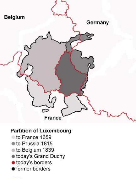
Map showing the partition of Luxembourg through the centuries with english explanations. The image is a modification of the image LuxembourgPartitionsMap.png by user:QuartierLatin1968 14:10, 22 Apr 2005 (UTC).
- Author of this image: user:Spanish_Inquisition
- Date: 3rd September 2006
[edit] Licensing
| I, the copyright holder of this work, hereby release it into the public domain. This applies worldwide. In case this is not legally possible: Afrikaans | Alemannisch | Aragonés | العربية | Asturianu | Български | Català | Česky | Cymraeg | Dansk | Deutsch | Eʋegbe | Ελληνικά | English | Español | Esperanto | Euskara | Estremeñu | فارسی | Français | Galego | 한국어 | हिन्दी | Hrvatski | Ido | Bahasa Indonesia | Íslenska | Italiano | עברית | Kurdî / كوردی | Latina | Lietuvių | Latviešu | Magyar | Македонски | Bahasa Melayu | Nederlands | Norsk (bokmål) | Norsk (nynorsk) | 日本語 | Polski | Português | Ripoarisch | Română | Русский | Shqip | Slovenčina | Slovenščina | Српски / Srpski | Svenska | ไทย | Tagalog | Türkçe | Українська | Tiếng Việt | Walon | 中文(简体) | 中文(繁體) | zh-yue-hant | +/- |
File history
Click on a date/time to view the file as it appeared at that time.
| Date/Time | Dimensions | User | Comment | |
|---|---|---|---|---|
| current | 14:58, 3 September 2006 | 433×569 (82 KB) | Spanish Inquisition | (Map showing the partition of Luxembourg thorugh the centuries with english expanantions. Modification of the image LuxembourgPartitionsMap.png by user:QuartierLatin1968 14:10, 22 Apr 2005 (UTC). Author: user:Spanish_Inquisition Date: 3rd September 2006) |
File links
Metadata
This file contains additional information, probably added from the digital camera or scanner used to create or digitize it. If the file has been modified from its original state, some details may not fully reflect the modified file.
| Orientation | Normal |
|---|---|
| Horizontal resolution | 119 dpi |
| Vertical resolution | 119 dpi |
| Software used | Adobe Photoshop 7.0 |
| File change date and time | 16:24, 3 September 2006 |
| Color space | sRGB |

