Image:Luxembourg-CIA WFB Map.png
From Wikipedia, the free encyclopedia
No higher resolution available.
Luxembourg-CIA_WFB_Map.png (328 × 351 pixels, file size: 8 KB, MIME type: image/png)
| | This is a file from the Wikimedia Commons. The description on its description page there is shown below.
|
| Description |
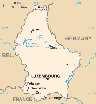
CIA World Factbook map of Luxembourg |
|||||
|---|---|---|---|---|---|---|
| Source | ||||||
| Date |
10 January 2006 |
|||||
| Author |
CIA |
|||||
| Permission (Reusing this image) |
|

 |
This map image should be recreated using vector graphics as an SVG file. This has several advantages; see Commons:Media for cleanup for more information. If an SVG form of this image is already available, please upload it. After uploading an SVG, replace this template with template {{Vector version available|new image name.svg}} in this image. |
|
العربية | Български | Català | Česky | Dansk | Deutsch | English | Esperanto | Español | Français | 한국어 | Italiano | Magyar | Lietuvių | Nederlands | 日本語 | Polski | Português | Română | Русский | Suomi | Svenska | Türkçe | Українська | Tiếng Việt | मराठी | 中文(繁體) | 中文(简体) | +/- |
|
File history
Click on a date/time to view the file as it appeared at that time.
| Date/Time | Dimensions | User | Comment | |
|---|---|---|---|---|
| current | 16:29, 4 May 2007 | 328×351 (8 KB) | Tene | (Optimised (0)) |
| 08:51, 30 January 2006 | 328×351 (9 KB) | Hoshie | (Updated map of Luxembourg from the CIA World Factbook, 10 Jan 06, rev: http://www.cia.gov/cia/publications/factbook/maps/lu-map.gif) | |
| 09:15, 27 March 2005 | 330×354 (7 KB) | Wolfman | ({{CIA-map}}) |

