Image:LongIslandSoundDrainageBasinsUSEPA.jpg
From Wikipedia, the free encyclopedia
No higher resolution available.
LongIslandSoundDrainageBasinsUSEPA.jpg (509 × 427 pixels, file size: 70 KB, MIME type: image/jpeg)
[edit] Summary
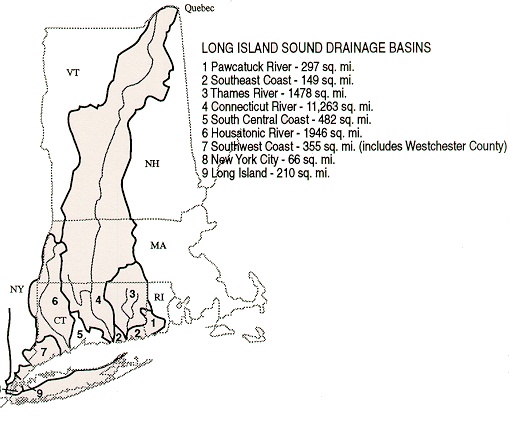
Map of Watershed of Long Island Sound
In this map, the section labeled "9" (Long Island) is miscolored. The part of Long Island that drains into the Sound is to the north of the line, not to the south, and amounts to a small fraction of the entire area of Long Island.
Source: Website of the U.S. Environmental Protection Agency
http://www.epa.gov/region01/eco/lis/assets/images/abasin.jpg
[edit] Licensing
| This work is in the public domain in the United States because it is a work of the United States Federal Government under the terms of Title 17, Chapter 1, Section 105 of the US Code. See Copyright. Note: This only applies to works of the Federal Government and not to the work of any individual U.S. state, territory, commonwealth, county, municipality, or any other subdivision. |
 |
File history
Click on a date/time to view the file as it appeared at that time.
| Date/Time | Dimensions | User | Comment | |
|---|---|---|---|---|
| current | 01:37, 12 May 2007 | 509×427 (70 KB) | Noroton (Talk | contribs) | (Map of Watershed of Long Island Sound Source: Website of the U.S. Environmental Protection Agency http://www.epa.gov/region01/eco/lis/assets/images/abasin.jpg) |
- Search for duplicate files
- Edit this file using an external application
See the setup instructions for more information.
File links
The following pages on the English Wikipedia link to this file (pages on other projects are not listed):

