Image:LondonBexley.png
From Wikipedia, the free encyclopedia
No higher resolution available.
LondonBexley.png (200 × 155 pixels, file size: 23 KB, MIME type: image/png)
| | This is a file from the Wikimedia Commons. The description on its description page there is shown below.
|
| A vector version of this image is also available, and should be used in place of this raster image whenever possible. Note: this file will not be deleted for this reason, unless it is explicitly nominated for deletion. Deleting this image might break the “attribution path” for the new SVG image, which breaks licenses such as the GFDL. For more information about vector graphics, see the articles on vector and raster graphics. There is also information about MediaWiki's support of SVG images. |
 |
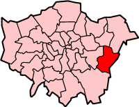
London Borough of Bexley
Map drawn by en:User:Morwen

File history
Click on a date/time to view the file as it appeared at that time.
| Date/Time | Dimensions | User | Comment | |
|---|---|---|---|---|
| current | 09:56, 9 April 2005 | 200×155 (23 KB) | Voyager | (London Borough of Bexley Map drawn by en:User:Morwen {{GFDL}} Category:Maps of London ) |
File links
The following pages on the English Wikipedia link to this file (pages on other projects are not listed):
- Bexleyheath
- Crayford
- Erith
- Sidcup
- Thamesmead
- Welling
- London Borough of Bexley
- Upton, London
- Bexley
- Belvedere, London
- Foots Cray
- Red House (London)
- New Eltham
- Falconwood
- Barnehurst
- Barnes Cray
- Danson House
- Category:Bexley
- Crossness
- Hall Place
- Albany Park, Bexley
- Blackfen
- Slade Green
- Northumberland Heath
- Abbey Wood
- Bexley parks and open spaces
- Crossness Pumping Station
- Lamorbey
- West Heath, London
- Lessness Heath
- Crook Log
- East Wickham
- Longlands
- Template:LB Bexley
- Foots Cray Meadows
- North Cray

