Image:Location ConfederaciónPerú-Boliviana.png
From Wikipedia, the free encyclopedia
No higher resolution available.
Location_ConfederaciónPerú-Boliviana.png (250 × 122 pixels, file size: 6 KB, MIME type: image/png)
| | This is a file from the Wikimedia Commons. The description on its description page there is shown below.
|
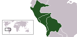
 Ubicación de la Confederación Perú-Boliviana.
 Location map of Peru-Bolivian Confederacy.

File history
Click on a date/time to view the file as it appeared at that time.
| Date/Time | Dimensions | User | Comment | |
|---|---|---|---|---|
| current | 11:52, 9 September 2006 | 250×122 (6 KB) | Conscious | (Reverted to earlier revision) |
| 11:51, 9 September 2006 | 250×122 (5 KB) | Conscious | (version from en:, by en:User:RapaNui, GFDL) | |
| 00:32, 12 March 2006 | 250×122 (6 KB) | ThrashedParanoid | (Fixed the lines) | |
| 21:20, 1 February 2006 | 250×122 (5 KB) | Huhsunqu | ||
| 17:18, 12 June 2005 | 250×122 (5 KB) | Huhsunqu | (250px version) | |
| 17:06, 12 June 2005 | 281×122 (5 KB) | Huhsunqu | ({{es icon}} Ubicación de la Confederación Perú-Boliviana. {{en icon}} Location map of Peru-Bolivian Confederacy. {{GFDL-self}} Category:Maps of South America) |
File links
The following pages on the English Wikipedia link to this file (pages on other projects are not listed):

