Image:LocationSouthAfrica-1990.png
From Wikipedia, the free encyclopedia
No higher resolution available.
LocationSouthAfrica-1990.png (250 × 115 pixels, file size: 5 KB, MIME type: image/png)
| | This is a file from the Wikimedia Commons. The description on its description page there is shown below.
|
[edit] Summary
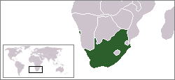
A locator map of South Africa showing en:Walvis Bay. This locator map is intended for South African articles taking place before the transfer of Walvis Bay to Nambia in 1994. The orginal map is by Vardion. Since that map is PD, this one is well.
[edit] Licensing
| This image has been released into the public domain by its author, Hoshie. This applies worldwide. In some countries this may not be legally possible; if so: العربية | Български | Deutsch | Ελληνικά | English | Español | Français | Italiano | 日本語 | 한국어 | Polski | Русский | Српски / Srpski | Svenska | தமிழ் | Українська | 中文(繁體) | 中文(简体) +/- |
File history
Click on a date/time to view the file as it appeared at that time.
| Date/Time | Dimensions | User | Comment | |
|---|---|---|---|---|
| current | 03:34, 16 August 2006 | 250×115 (5 KB) | Hoshie | (== Summary == A locator map of South Africa showing en:Walvis Bay. This locator map is intended for South African articles taking place before the transfer of Walvis Bay to Nambia in 1994. The orginal map is by [[Us) |
File links
The following pages on the English Wikipedia link to this file (pages on other projects are not listed):

