Image:LocationGilbert.png
From Wikipedia, the free encyclopedia
No higher resolution available.
LocationGilbert.png (250 × 158 pixels, file size: 4 KB, MIME type: image/png)
| | This is a file from the Wikimedia Commons. The description on its description page there is shown below.
|
[edit] Summary
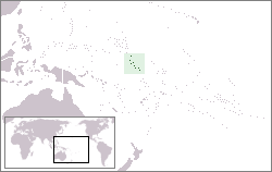
Location map for the Gilbert Islands within Kiribati.
[edit] Licensing
|
File history
Click on a date/time to view the file as it appeared at that time.
| Date/Time | Dimensions | User | Comment | |
|---|---|---|---|---|
| current | 20:10, 19 December 2006 | 250×158 (4 KB) | Kmusser | (== Summary == Location map for the Gilbert Islands within Kiribati. Category:Maps of Kiribati == Licensing == {{self|cc-by-sa-2.5}}) |
File links
The following pages on the English Wikipedia link to this file (pages on other projects are not listed):

