Image:LocationCzechoslovakia.png
From Wikipedia, the free encyclopedia
No higher resolution available.
LocationCzechoslovakia.png (250 × 229 pixels, file size: 10 KB, MIME type: image/png)
| | This is a file from the Wikimedia Commons. The description on its description page there is shown below.
|
| Description |
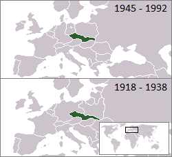
Location of Czechoslovakia 1918–1938 and 1945–1992 |
|---|---|
| Source |
From en.wikipedia |
| Date | |
| Author |
First uploaded to en: by en:User:Morwen, extended to the "first republic" by en:User:Hexagon1. |
| Permission (Reusing this image) |
see below |
 |
This map image should be recreated using vector graphics as an SVG file. This has several advantages; see Commons:Media for cleanup for more information. If an SVG form of this image is already available, please upload it. After uploading an SVG, replace this template with template {{Vector version available|new image name.svg}} in this image. |
|
العربية | Български | Català | Česky | Dansk | Deutsch | English | Esperanto | Español | Français | 한국어 | Italiano | Magyar | Lietuvių | Nederlands | 日本語 | Polski | Português | Română | Русский | Suomi | Svenska | Türkçe | Українська | Tiếng Việt | 中文(繁體) | 中文(简体) | +/- |
|
| I, the copyright holder of this work, hereby release it into the public domain. This applies worldwide. In case this is not legally possible: Afrikaans | Alemannisch | Aragonés | العربية | Asturianu | Български | Català | Česky | Cymraeg | Dansk | Deutsch | Eʋegbe | Ελληνικά | English | Español | Esperanto | Euskara | Estremeñu | فارسی | Français | Galego | 한국어 | हिन्दी | Hrvatski | Ido | Bahasa Indonesia | Íslenska | Italiano | עברית | Kurdî / كوردی | Latina | Lietuvių | Latviešu | Magyar | Македонски | Bahasa Melayu | Nederlands | Norsk (bokmål) | Norsk (nynorsk) | 日本語 | Polski | Português | Ripoarisch | Română | Русский | Shqip | Slovenčina | Slovenščina | Српски / Srpski | Svenska | ไทย | Tagalog | Türkçe | Українська | Tiếng Việt | Walon | 中文(简体) | 中文(繁體) | zh-yue-hant | +/- |
File history
Click on a date/time to view the file as it appeared at that time.
| Date/Time | Dimensions | User | Comment | |
|---|---|---|---|---|
| current | 02:57, 30 May 2007 | 250×229 (10 KB) | Hexagon1 | (larger dates) |
| 02:41, 30 May 2007 | 250×229 (9 KB) | Hexagon1 | (fx) | |
| 02:40, 30 May 2007 | 250×229 (10 KB) | Hexagon1 | (borders corrected (correct as of 1921)) | |
| 01:13, 23 January 2007 | 250×229 (9 KB) | Hexagon1 | (rv, even though the borders of the surrounding nations changed, that entire period saw borders transition as independences were recognized left, right and centre. I think it's wise to omit these changes because we simply can't have enough boxes to progres) | |
| 08:24, 20 January 2007 | 249×344 (14 KB) | Hoshie | (added a box for post-communist Czechoslovakia. under same license as original.) | |
| 01:22, 26 November 2006 | 250×229 (9 KB) | Hexagon1 | (added 1918 to 1938 box) | |
| 10:27, 20 March 2005 | 250×115 (3 KB) | Thuresson | ({{GFDL}}) |

