Image:LocationCentralAfricanEmpire.png
From Wikipedia, the free encyclopedia
No higher resolution available.
LocationCentralAfricanEmpire.png (250 × 115 pixels, file size: 6 KB, MIME type: image/png)
| | This is a file from the Wikimedia Commons. The description on its description page there is shown below.
|
[edit] Summary
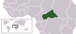
This is a map of the Central African Empire. This map is virtually the same as User:Vardion's location map of the Central African Republic with only two changes. Eritrea and Ethiopia are one country (the Central African Empire existed from 1976-79) and Cabinda (Angola) is included as as well. As the orginal map was PD, this one is too.
[edit] Licensing
| I, Hoshie, the copyright holder of this work, hereby release it into the public domain. This applies worldwide. In case this is not legally possible: Afrikaans | Alemannisch | Aragonés | العربية | Asturianu | Български | Català | Česky | Cymraeg | Dansk | Deutsch | Eʋegbe | Ελληνικά | English | Español | Esperanto | Euskara | Estremeñu | فارسی | Français | Galego | 한국어 | हिन्दी | Hrvatski | Ido | Bahasa Indonesia | Íslenska | Italiano | עברית | Kurdî / كوردی | Latina | Lietuvių | Latviešu | Magyar | Македонски | Bahasa Melayu | Nederlands | Norsk (bokmål) | Norsk (nynorsk) | 日本語 | Polski | Português | Ripoarisch | Română | Русский | Shqip | Slovenčina | Slovenščina | Српски / Srpski | Svenska | ไทย | Tagalog | Türkçe | Українська | Tiếng Việt | Walon | 中文(简体) | 中文(繁體) | zh-yue-hant | +/- |
File history
Click on a date/time to view the file as it appeared at that time.
| Date/Time | Dimensions | User | Comment | |
|---|---|---|---|---|
| current | 05:47, 27 July 2007 | 250×115 (6 KB) | Hoshie | (This is a map of the Central African Empire. This map is virtually the same as User:Vardion's location map of the Central African Republic with only two changes. Eritrea and ) |

