Image:Litla dimun map.jpg
From Wikipedia, the free encyclopedia
No higher resolution available.
Litla_dimun_map.jpg (401 × 273 pixels, file size: 21 KB, MIME type: image/jpeg)
| | This is a file from the Wikimedia Commons. The description on its description page there is shown below.
|
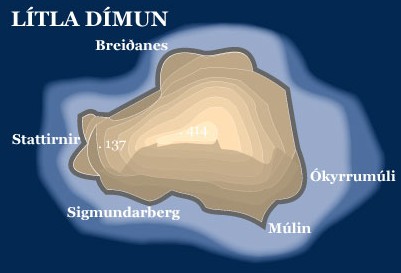
- Topopgraphic map of the island of Lítla Dímun, Faroe Islands
- Graphics: Anker Eli Petersen
- Source: Faroestamps.fo
| This image is in the public domain because it was released by the copyright holder Postverk Føroya - Philatelic Office. More information here
|
|
File history
Click on a date/time to view the file as it appeared at that time.
| Date/Time | Dimensions | User | Comment | |
|---|---|---|---|---|
| current | 08:28, 28 June 2005 | 401×273 (21 KB) | Arne List | (*Topopgraphic map of the island of Lítla Dímun, Faroe Islands *Graphics: Anker Eli Petersen *Source: [http://www.faroestamps.fo/?side=cf860f1610d1ec7342844c79d9ddd36e Faroestamps.fo] {{PD}}) |
File links
The following pages on the English Wikipedia link to this file (pages on other projects are not listed):

