Image:Levant 01.PNG
From Wikipedia, the free encyclopedia
Size of this preview: 505 × 599 pixels
Full resolution (707 × 839 pixels, file size: 82 KB, MIME type: image/png)
| | This is a file from the Wikimedia Commons. The description on its description page there is shown below.
|
 |
This map has been uploaded by Electionworld from en.wikipedia.org to enable the |
[edit] Summary
Created by ChrisRy5 using Macromedia Flash. City locations found on Wikipedia.
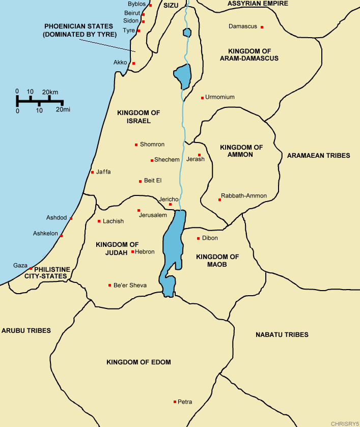
Map showing the ancient levant borders and ancient cities such as Urmomium and Jerash. The map also shows the region in the 9th century BCE. Notice the coastal land of Philistia, from which the name "Palestine" derives.
[edit] Licensing
| This image has been released into the public domain by its author, ChrisRy5. This applies worldwide. In some countries this may not be legally possible; if so: العربية | Български | Deutsch | Ελληνικά | English | Español | Français | Italiano | 日本語 | 한국어 | Polski | Русский | Српски / Srpski | Svenska | தமிழ் | Українська | 中文(繁體) | 中文(简体) +/- |
File history
Click on a date/time to view the file as it appeared at that time.
| Date/Time | Dimensions | User | Comment | |
|---|---|---|---|---|
| current | 14:53, 18 December 2006 | 707×839 (82 KB) | Electionworld | ({{ew|en|ChrisRy5}} == Summary == Created by ChrisRy5 using Macromedia Flash. City locations found on Wikipedia.<BR>Map showing the ancient levant borders and ancient cities such as Urmomium and Jerash. The map also shows the region in the 9th cent) |
File links
No pages on the English Wikipedia link to this file. (Pages on other projects are not counted.)

