Lake Manantali
From Wikipedia, the free encyclopedia
| Lake Manantali | |
|---|---|
 |
|
| Coordinates | |
| Lake type | artificial |
| Primary inflows | Bafing River |
| Primary outflows | Bafing River |
| Basin countries | Mali |
| Surface area | 477 km² |
| Water volume | 11.3 billion m³ |
| Settlements | Manantali, Tondidji |
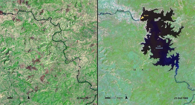
Lake Manantali is a large artificial lake, formed by the 1989 construction of the Manantali Dam, on the Bafing River in Mali. Its northern point is located 90 km to the south-east of the city of Bafoulabé.
[edit] Size
Lake Manantali covers 477 km² and contains 11.3 billion m³ of water. Its formation forced 12,000 people from their homes and flooded 120 km² of forest. The lake largely ended the flood patterns on both the Bafing and Senegal Rivers, compromising traditional agriculture which depended upon seasonal flooding. The lake has created benefits as well: consistent navigation downstream of the dam, use of for irrigation of surrounding land, and a source for commercial fishing. The dam itself provides hydroelectric power through much of the region.[1]
[edit] References
- Knaap, M. van der. Status of fish stocks and fisheries of thirteen medium-sized African reservoirs. CIFA Technical Paper. No. 26. Rome, FAO. 1994. 107p.
- William R. Jobin (1999). Dams and Disease: Ecological Design and Health Impacts of Large Dams, Canals, and Irrigation Systems. Taylor & Francis. ISBN 0419223606.

