Image:Lake Pontchartrain Georges.jpg
From Wikipedia, the free encyclopedia
Size of this preview: 800 × 492 pixels
Full resolution (824 × 507 pixels, file size: 87 KB, MIME type: image/jpeg)
| | This is a file from the Wikimedia Commons. The description on its description page there is shown below.
|
Transwiki approved by: w:en:User:Dmcdevit
This image was copied from wikipedia:en. The original description was:
| This image is in the public domain because it contains materials that originally came from the United States Army Corps of Engineers. |
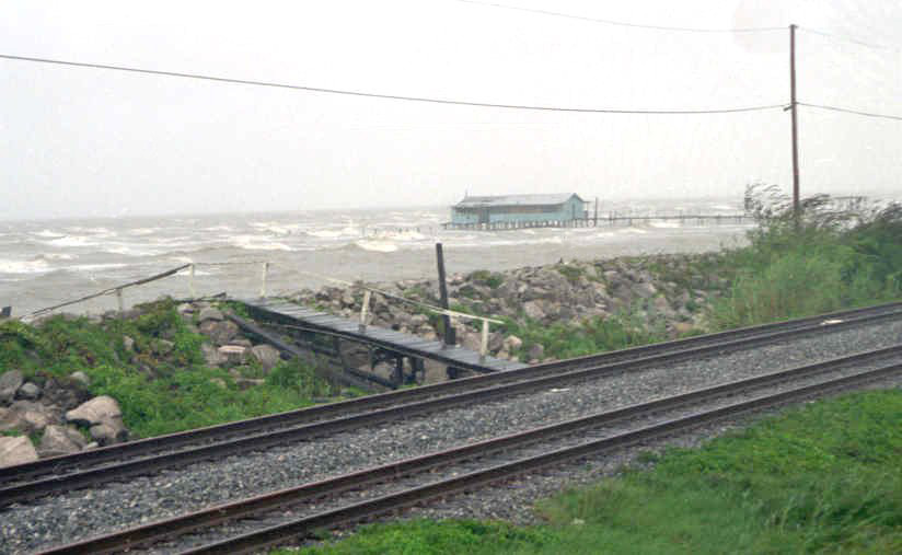
w:en:Lake Pontchartrain at w:en:New Orleans during w:en:Hurricane Georges, w:en:28 September w:en:1998.
Original caption: "Camp on Lake Pontchartrain off Hayne Blvd."
This is looking north east from atop the flood protection levee, Eastern New Orleans. Most of the old "camps" (houses built on stilts in the shallows of the lake), some of which had been in existence for generations, were destroyed during Georges.
Retrieved from http://www.mvn.usace.army.mil/ops/georges/pictures.htm (file is http://www.mvn.usace.army.mil/ops/georges/pix/Lake01.jpg).
[edit] File history
| date/time | username | resolution | size | edit summary |
|---|---|---|---|---|
| 03:58, 31 October 2005 | w:en:User:Malepheasant | 824×507 | 87 KB | {{PD-USGov-Military-Army-USACE}} <a href="/wiki/Lake_Pontchartrain" title="Lake Pontchartrain">Lake Pontchartrain</a> at <a href="/wiki/New_Orleans" title="New Orleans">New Orleans</a> during <a href="/wiki/Hurricane_Georges" title="Hurricane Georges">Hurricane Georges</a>, <a href="/wiki/28_September" title="28 September">28 September</a> <a href="/wiki/1998" title="1998">1998</a>. Retrieved from http://www.mvn.usace.army.mil/ops/georges/pictures.htm (file is http://www.mvn.usace.army.mil/ops/georges/ |
[edit] Image description page history
| link | date/time | username | edit summary |
|---|---|---|---|
| http://en.wikipedia.org/w/index.php?title=Image:Lake_Pontchartrain_Georges.jpg&redirect=no&oldid=118631088 | 09:24, 12 September 2007 | w:en:User:Dmcdevit | |
| http://en.wikipedia.org/w/index.php?title=Image:Lake_Pontchartrain_Georges.jpg&redirect=no&oldid=118631088 | 22:33, 28 March 2007 | w:en:User:CmdrObot | |
| http://en.wikipedia.org/w/index.php?title=Image:Lake_Pontchartrain_Georges.jpg&redirect=no&oldid=58976357 | 18:00, 16 June 2006 | w:en:User:Infrogmation | |
| http://en.wikipedia.org/w/index.php?title=Image:Lake_Pontchartrain_Georges.jpg&redirect=no&oldid=26943548 | 03:58, 31 October 2005 | w:en:User:Malepheasant | ({{PD-USGov-Military-Army-USACE}} <a href="/wiki/Lake_Pontchartrain" title="Lake Pontchartrain">Lake Pontchartrain</a> at <a href="/wiki/New_Orleans" title="New Orleans">New Orleans</a> during <a href="/wiki/Hurricane_Georges" title="Hurricane Georges">Hurricane Georges</a>, <a href="/wiki/28_September" title="28 September">28 September</a> <a href="/wiki/1998" title="1998">1998</a>. Retrieved from http://www.mvn.usace.army.mil/ops/georges/pictures.htm (file is http://www.mvn.usace.army.mil/ops/georges/) |
File history
Click on a date/time to view the file as it appeared at that time.
| Date/Time | Dimensions | User | Comment | |
|---|---|---|---|---|
| current | 15:36, 13 September 2007 | 824×507 (87 KB) | BetacommandBot | (Transwiki approved by: w:en:User:Dmcdevit This image was copied from wikipedia:en. The original description was: {{PD-USGov-Military-Army-USACE}} w:en:Lake Pontchartrain at w:en:New Orleans during w:en:Hurricane Georges, [[w:en:28 Septe) |
File links
The following pages on the English Wikipedia link to this file (pages on other projects are not listed):

