Image:LakeKivu satellite.jpg
From Wikipedia, the free encyclopedia
No higher resolution available.
LakeKivu_satellite.jpg (295 × 476 pixels, file size: 108 KB, MIME type: image/jpeg)
| | This is a file from the Wikimedia Commons. The description on its description page there is shown below.
|
[edit] Summary
from en.wiki
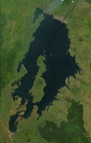
Lake Kivu, Africa, as seen from space. Cropped from a larger image (EAfrica.A2003033.0820.250m.jpg). http://visibleearth.nasa.gov
The black line marks the border between Rwanda and the Democratic Republic of the Congo
Uploaded on 23 February 2006 by en:User:Paphrag.
[edit] Licensing
|
|
This file is in the public domain because it was created by NASA. NASA copyright policy states that "NASA material is not protected by copyright unless noted". (NASA copyright policy page or JPL Image Use Policy).
Deutsch | English | Español | Français | Nederlands | Português | Русский | 中文(简体) | 中文(繁體) | +/- |
|
 |
Warnings:
|
File history
Click on a date/time to view the file as it appeared at that time.
| Date/Time | Dimensions | User | Comment | |
|---|---|---|---|---|
| current | 22:43, 24 May 2006 | 295×476 (108 KB) | Dubhe | (from en.wiki) |
File links
The following pages on the English Wikipedia link to this file (pages on other projects are not listed):
Metadata
This file contains additional information, probably added from the digital camera or scanner used to create or digitize it. If the file has been modified from its original state, some details may not fully reflect the modified file.
| Orientation | Normal |
|---|---|
| Horizontal resolution | 72 dpi |
| Vertical resolution | 72 dpi |
| Software used | Adobe Photoshop CS Macintosh |
| File change date and time | 14:46, 23 February 2006 |
| Color space | sRGB |

