Image:L&NE on US map cropped.png
From Wikipedia, the free encyclopedia
No higher resolution available.
L&NE_on_US_map_cropped.png (300 × 227 pixels, file size: 9 KB, MIME type: image/png)
| | This is a file from the Wikimedia Commons. The description on its description page there is shown below.
|
|

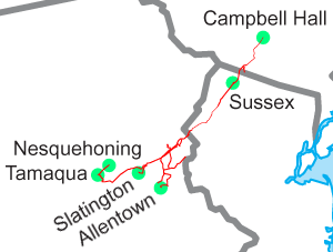
Lehigh and New England Railroad on Image:US state outline map.png. See Image:L&NE on US map.png for the full U.S.
File history
Click on a date/time to view the file as it appeared at that time.
| Date/Time | Dimensions | User | Comment | |
|---|---|---|---|---|
| current | 19:37, 23 July 2005 | 300×227 (9 KB) | SPUI | ({{spuimap}} Lehigh and New England Railroad on Image:US state outline map.png. See Image:L&NE on US map.png for the full U.S. category:Lehigh and New England Railroad category:railroad maps ) |
File links
The following pages on the English Wikipedia link to this file (pages on other projects are not listed):

