Image:Kyoto Metro Map.png
From Wikipedia, the free encyclopedia
No higher resolution available.
Kyoto_Metro_Map.png (510 × 510 pixels, file size: 8 KB, MIME type: image/png)
| | This is a file from the Wikimedia Commons. The description on its description page there is shown below.
|
English:
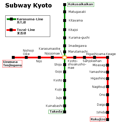
- Description: Map of Kyoto subway
- Author: User:Jcornelius
- 2005
- License: GFDL
Deutsch:
- Beschreibung: Karte der U-Bahn von Kyoto
- Autor: User:Jcornelius
- 2005
- Lizenz: GFDL

File history
Click on a date/time to view the file as it appeared at that time.
| Date/Time | Dimensions | User | Comment | |
|---|---|---|---|---|
| current | 13:02, 22 December 2007 | 510×510 (8 KB) | Noddy93 | (-author/licensing information) |
| 07:53, 14 May 2005 | 510×510 (9 KB) | Jcornelius | ({{English}} * Description: Map of Kyoto subway * Author: User:Jcornelius * 2005 * License: GFDL {{German}} * Beschreibung: Karte der U-Bahn von Kyoto * Autor: User:Jcornelius * 2005 * Lizenz: GFDL {{GFDL}}) | |
| 07:53, 14 May 2005 | 510×510 (9 KB) | Jcornelius | ({{English}} * Description: Map of Kyoto subway * Author: User:Jcornelius * 2005 * License: GFDL {{German}} * Beschreibung: Karte der U-Bahn von Kyoto * Autor: User:Jcornelius * 2005 * Lizenz: GFDL {{GFDL}}) |
File links
The following pages on the English Wikipedia link to this file (pages on other projects are not listed):

