Image:KMDW Airport Map.png
From Wikipedia, the free encyclopedia
Size of this preview: 419 × 600 pixels
Full resolution (779 × 1,115 pixels, file size: 123 KB, MIME type: image/png)
| | This is a file from the Wikimedia Commons. The description on its description page there is shown below.
|
 |
This image was moved to Wikimedia Commons from en.wikipedia using a bot script. All source information is still present. It requires review because CommonSense could not categorise the image during transfer. Additionally, there may be errors in any or all of the information fields; information on this image should not be considered reliable and the image should not be used until it has been reviewed and any needed corrections have been made. Once the review has been completed, this template should be removed. For details, see below. |
| Description |
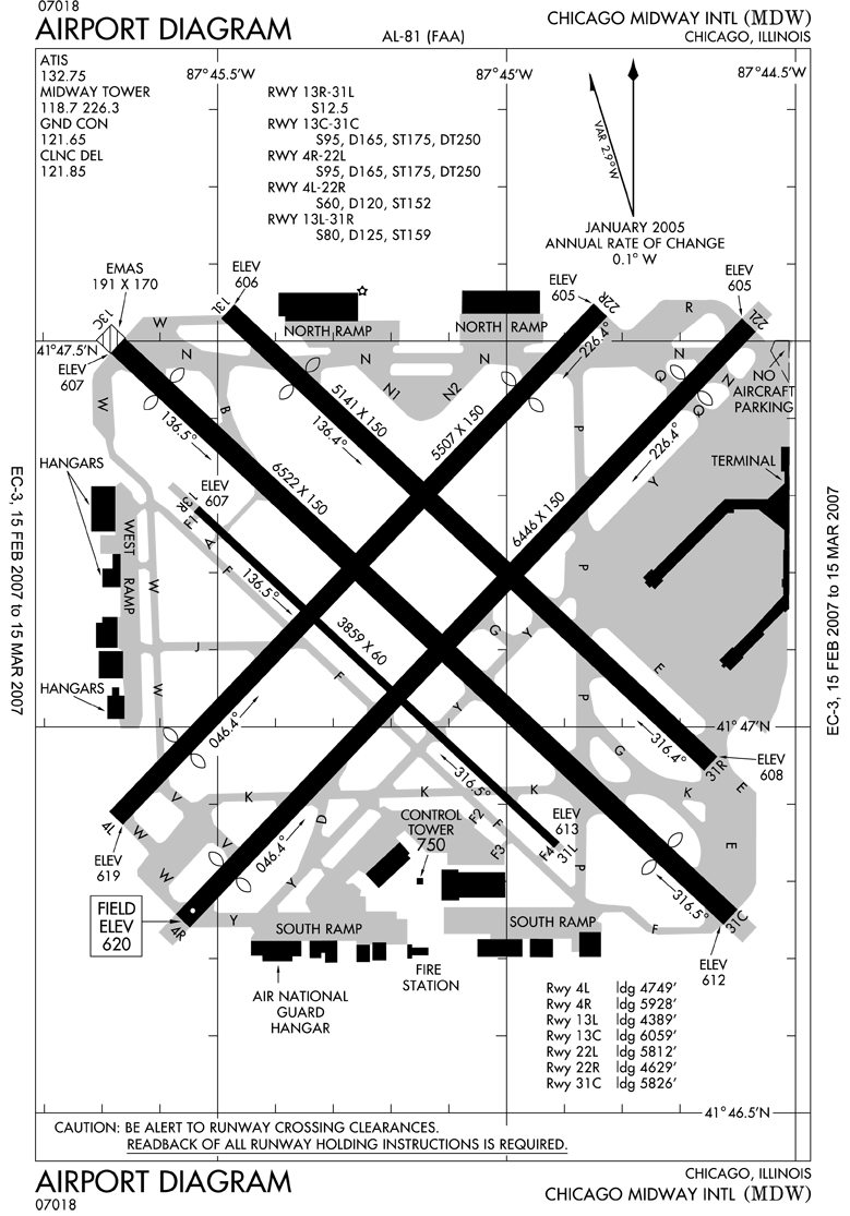
English: FAA diagram for en:Chicago Midway International Airport (MDW) in Chicago, Illinois, United States.
en:commons:category:Chicago Midway International Airport en:commons:category:Federal Aviation Administration en:commons:category:Maps en:Category:Airports in the United States en:Category:Airport map |
|---|---|
| Source |
Transferred from en.wikipedia; transfered to Commons by User:Alaney2k using CommonsHelper. |
| Date |
2007-02-16 (original upload date) |
| Author |
National Aeronautical Charting Office (NACO), a department of the en:Federal Aviation Administration (FAA). Original uploader was Phongn at en.wikipedia |
| Permission (Reusing this image) |
PD-USGOV-DOT-FAA; PD-USGOV-FAA. |
[edit] License information
| This image is a work of a Federal Aviation Administration employee, taken or made during the course of an employee's official duties. As works of the U.S. federal government, all FAA images are in the public domain. |  |
| This image is a work of a Federal Aviation Administration employee, taken or made during the course of an employee's official duties. As works of the U.S. federal government, all FAA images are in the public domain. | |
[edit] Original upload log
The original description page is/was here. All following user names refer to en.wikipedia.
- 2007-02-16 06:16 Phongn 779×1115×8 (126040 bytes) {{Information| |Description = FAA airport diagram for MDW (Chicago Midway International Airport) in Chicago, Illinois, United States. |Source = http://www.naco.faa.gov/index.asp?xml=naco/online/d_tpp |Date = Unknown. Effective: 15 February 2
File history
Click on a date/time to view the file as it appeared at that time.
| Date/Time | Dimensions | User | Comment | |
|---|---|---|---|---|
| current | 15:37, 3 June 2008 | 779×1,115 (123 KB) | File Upload Bot (Magnus Manske) | ( {{BotMoveToCommons|en.wikipedia}} {{Information |Description={{en|FAA diagram for en:Chicago Midway International Airport (MDW) in Chicago, Illinois, United States.<br/> en:commons:category:Chicago Midway International Airport [[:en:commons:ca) |

