Image:Inland empire within southern california.png
From Wikipedia, the free encyclopedia
No higher resolution available.
Inland_empire_within_southern_california.png (342 × 308 pixels, file size: 160 KB, MIME type: image/png)
| | This is a file from the Wikimedia Commons. The description on its description page there is shown below.
|
Transwiki approved by: w:en:User:Dmcdevit
This image was copied from wikipedia:en. The original description was:
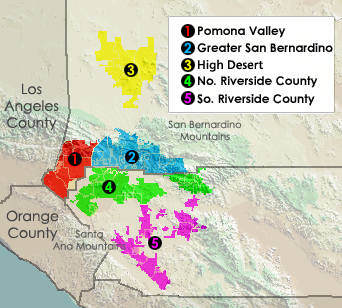
Displays different regions in Southern California's Inland Empire.
Created using Census Data, USGS imagery. put together by myself.
[edit] Licensing
| I, the copyright holder of this work, hereby release it into the public domain. This applies worldwide. In case this is not legally possible: Afrikaans | Alemannisch | Aragonés | العربية | Asturianu | Български | Català | Česky | Cymraeg | Dansk | Deutsch | Eʋegbe | Ελληνικά | English | Español | Esperanto | Euskara | Estremeñu | فارسی | Français | Galego | 한국어 | हिन्दी | Hrvatski | Ido | Bahasa Indonesia | Íslenska | Italiano | עברית | Kurdî / كوردی | Latina | Lietuvių | Latviešu | Magyar | Македонски | Bahasa Melayu | Nederlands | Norsk (bokmål) | Norsk (nynorsk) | 日本語 | Polski | Português | Ripoarisch | Română | Русский | Shqip | Slovenčina | Slovenščina | Српски / Srpski | Svenska | ไทย | Tagalog | Türkçe | Українська | Tiếng Việt | Walon | 中文(简体) | 中文(繁體) | zh-yue-hant | +/- |
| This image or other media is a work of a United States Census Bureau employee, taken or made during the course of an employee's official duties. As a work of the U.S. federal government, the image is in the public domain |  |
| This image is in the public domain because it contains materials that originally came from the United States Geological Survey, an agency of the United States Department of Interior. For more information, see the official USGS copyright policy |
|
[edit] File history
03:58, 24 December 2005 || w:en:User:Ab189|| 342×308 || 19 KB || 03:54, 24 December 2005 || w:en:User:Ab189|| 342×308 || 19 KB || Displays different regions in Southern California's Inland Empire. Created using Census Data. {{PD-self}} {{PD-USGov-DOC-Census}}
| date/time | username | resolution | size | edit summary |
|---|---|---|---|---|
| 07:44, 5 March 2006 | w:en:User:Ab189 | 342×308 | 160 KB | Relief map is a work by the USGS, boundaries drawn by the US Census, put together by me. {{PD-USGov-Interior-USGS}} {{PD-USGov-DOC-Census}} |
[edit] Image description page history
File history
Click on a date/time to view the file as it appeared at that time.
| Date/Time | Dimensions | User | Comment | |
|---|---|---|---|---|
| current | 04:05, 16 September 2007 | 342×308 (160 KB) | BetacommandBot | (Transwiki approved by: w:en:User:Dmcdevit This image was copied from wikipedia:en. The original description was: Displays different regions in Southern California's Inland Empire. Created using Census Data, USGS imagery. put together by myself. ==) |

