Image:India average annual temperature map en.svg
From Wikipedia, the free encyclopedia

India_average_annual_temperature_map_en.svg (SVG file, nominally 1639 × 1852 pixels, file size: 366 KB)
| | This is a file from the Wikimedia Commons. The description on its description page there is shown below.
|
![]() Click here if you are having problems with this file
Click here if you are having problems with this file![]()
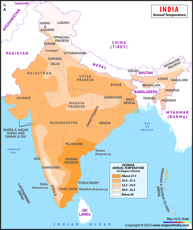
| WikiProject India Maps |
India average annual temperature map english version |
|---|---|
| Description |
Map showing zones shaded by average annual temperatures in India |
| Source |
International Borders: University of Texas map library[1]- India Political map 2001 |
| Date |
March 2007 |
| Author | |
| License |

Contents |
[edit] Legend

[edit] Notes
Projection: Lambert Conical Orthomorphic
[edit] Explanation of disputed boundaries
- Boundary of Indian claim : The extent upto which the Indian administration claims as rightfully theirs, but is not recognised by China and Pakistan.
- Line of Control : The defacto boundary recognised by the international community, but not by India, China and Pakistan. This boundary is a temporary solution to the ongoing conflict.
[edit] Borders of disputed regions
The extent of Indian territory depicted on this map may not be accepted by some countries as legal due to ongoing border disputes:
- The northern state of Jammu & Kashmir is claimed entirely by both India and Pakistan (Azad Kashmir) and partly by China (Aksai Chin). It is currently divided between all three countries. See also Line of Control and Line of Actual Control.
- Siachen glacier (shown white) is an actively contested region between India and Pakistan. At present the region is in control of the Indian Army.
- The north eastern state of Arunachal Pradesh is almost entirely claimed by China as part of its territory. The state is recognised as a part of India by every country except China. See also McMahon Line.
Borders of some minor disputed areas have been omitted for the sake of simplicity:
- Minor areas of Jammu & Kashmir, Himachal Pradesh and Uttarakhand on the Chinese frontier are claimed by China. These areas are under Indian control.
- A small area of Uttarakhand adjoining the Nepal border along the Sarda river is disputed between the two countries.
For a detailed map of all disputed regions in India, see Image:India disputed areas map.svg
[edit] Internal borders
The borders of the state of Meghalaya, Assam and Arunachal Pradesh is shown as interpreted from the North-Eastern Areas (Reorganisation) Act, 1971, but has yet to be verified.
[edit] Territorial Waters
The limit of the territorial waters of India extends to twelve nautical miles measured from the appropriate baseline. See this for more information.
[edit] SVG Support
This document is in the Scalable Vector Graphic format (SVG) and requires a supported browser (Opera 9, Firefox 2) or a SVG plugin for Internet Explorer and other browsers. SVG is an open source format, which means this map can be downloaded and modified/translated completely using a vector graphics editor like Adobe Illustrator or Inkscape (free) or a text editor such as Notepad.
| BLANK THUMBNAIL | View large PNG | View medium PNG | SVG Plugin for Internet Explorer and other browsers |
|---|---|---|---|
| Click here (purge cache) and then CTRL+F5 to reload. Help? | Try 1 Try 2 | Try 1 Try 2 | Adobe SVG plugin |
| Recommended browser | More Help | ||
| Opera 9.1 | List of SVG tools |
[edit] Errata
If you notice a mistake on the map, please list them here. Please mention the name of the map to be corrected also.
- Uttaranchal is now Uttarakhand
- Pondicherry is now Puducherry
- The capital of the Union Territory of Daman and Diu is at Daman and not Diu.
- The Romanization/pinyin of Tibet is not Xijang, it is Xizang.
File history
Click on a date/time to view the file as it appeared at that time.
| Date/Time | Dimensions | User | Comment | |
|---|---|---|---|---|
| current | 02:35, 12 July 2007 | 1,639×1,852 (366 KB) | Abecedare | (Uttaranchal -> Uttarakhand; Pondicherry -> Puducherry ) |
| 04:13, 21 March 2007 | 1,639×1,852 (366 KB) | Saravask | ({{WikiProject_India_Maps |Title=India average annual temperature map english version |Description=Map showing zones shaded by average annual temperatures in India |Source=Traced from [http://www.mapsofindia.com/maps/india/india-map-annualtemperature.jpg i) | |
| 02:04, 21 March 2007 | 1,639×1,852 (366 KB) | Saravask | ({{WikiProject_India_Maps |Title=India average annual temperature map english version |Description=Map showing zones shaded by average annual temperatures in India |Source=Traced from [http://www.mapsofindia.com/maps/india/india-map-annualtemperature.jpg i) | |
| 16:53, 20 March 2007 | 1,639×1,852 (366 KB) | Saravask | ({{WikiProject_India_Maps |Title=India average annual temperature map english version |Description=Map showing zones shaded by average annual temperatures in India |Source=Traced from [http://www.mapsofindia.com/maps/india/india-map-annualtemperature.jpg i) |

