Image:Hurricane Fran.png
From Wikipedia, the free encyclopedia
No higher resolution available.
Hurricane_Fran.png (424 × 319 pixels, file size: 54 KB, MIME type: image/png)
| | This is a file from the Wikimedia Commons. The description on its description page there is shown below.
|
[edit] Summary
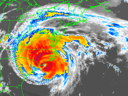
| Description |
Hurricane Fran at landfall near Cape Fear in North Carolina on September 5, 1996. Image is a color-enhanced IR scan from GOES-8. |
|||
|---|---|---|---|---|
| Source |
http://www1.ncdc.noaa.gov/pub/data/images/hurr-fran-goesir.gif |
|||
| Date |
1996-09-06 |
|||
| Author |
NOAA / National Climatic Data Center |
|||
| Permission (Reusing this image) |
|
File history
Click on a date/time to view the file as it appeared at that time.
| Date/Time | Dimensions | User | Comment | |
|---|---|---|---|---|
| current | 12:38, 15 August 2006 | 424×319 (54 KB) | Nilfanion | ({{Information| |Description= en:Hurricane Fran at landfall near en:Cape Fear in en:North Carolina on en:September 5, en:1996. Image is a color-enhanced IR scan from en:GOES-8. |Source=Satellite image via [[:e) |
File links
The following pages on the English Wikipedia link to this file (pages on other projects are not listed):

