Image:Hawaii population map.png
From Wikipedia, the free encyclopedia
No higher resolution available.
Hawaii_population_map.png (660 × 480 pixels, file size: 13 KB, MIME type: image/png)
| | This is a file from the Wikimedia Commons. The description on its description page there is shown below.
|
| Description |
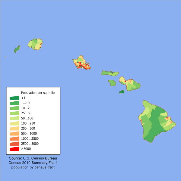
English: en:Category:U.S. State Population Maps
Hawaii state population density map based on Census 2000 data. See the data lineage for a process description.
|
|---|---|
| Source |
Transferred from en.wikipedia |
| Date |
2006-03-09 (original upload date) |
| Author |
Original uploader was JimIrwin at en.wikipedia |
| Permission (Reusing this image) |
Licensed under the GFDL by the author; Released under the GNU Free Documentation License. |
[edit] License information

[edit] Original upload log
The original description page is/was here. All following user names refer to en.wikipedia.
- 2006-03-09 21:48 JimIrwin 660×480×8 (12904 bytes) Hawaii state population density map based on Census 2000 data. See the [[User:JimIrwin/Lineage_of_population_maps|data lineage]] for a process description.
File history
Click on a date/time to view the file as it appeared at that time.
| Date/Time | Dimensions | User | Comment | |
|---|---|---|---|---|
| current | 01:04, 29 May 2008 | 660×480 (13 KB) | Viriditas | ({{Information |Description={{en|en:Category:U.S. State Population Maps en:Category:Hawaii maps == Summary == Hawaii state population density map based on Census 2000 data. See the data lineage fo) |
| 19:39, 12 May 2008 | 660×480 (13 KB) | File Upload Bot (Magnus Manske) | ( {{BotMoveToCommons|en.wikipedia}} {{Information |Description={{en|en:Category:U.S. State Population Maps en:Category:Hawaii maps Hawaii state population density map based on Census 2000 data. See the [[:en:User:JimIrwin/Lineage_of_population_) |
File links
The following pages on the English Wikipedia link to this file (pages on other projects are not listed):

