Image:Havelland FHSW.gif
From Wikipedia, the free encyclopedia
Size of this preview: 795 × 600 pixels
Full resolution (1,035 × 781 pixels, file size: 129 KB, MIME type: image/gif)
| | This is a file from the Wikimedia Commons. The description on its description page there is shown below.
|
[edit] Summary
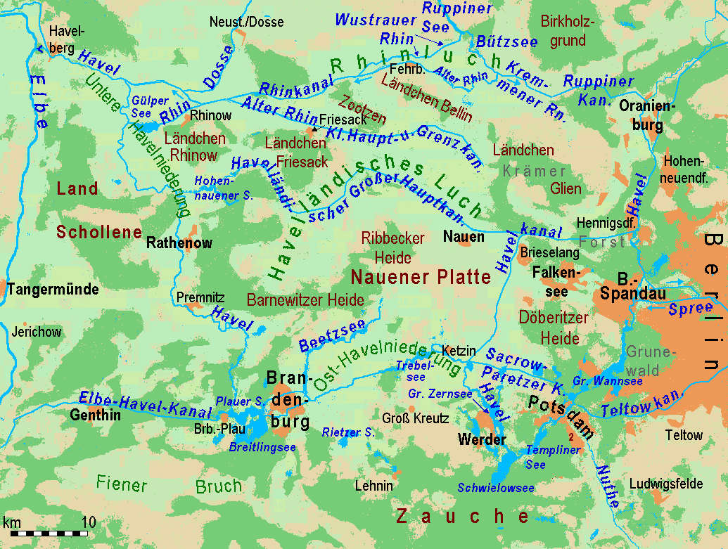
| Description |
Deutsch: Gliederung und Gewässernetz des Havellandes
English: Partition and waterways of Havelland region west of Berlin
|
|---|---|
| Source | |
| Date | |
| Author |
Ulamm 17:33, 28 February 2008 (UTC) |
| Permission (Reusing this image) |
see below |
| Other versions | Image:Havelland FHSW.gif
English: relief and waterbodies only
Deutsch: Basis: Relief und Gewässer
Image:Luche FHSW.gif English: Cut: Wetlands called "Luch"
Deutsch: Ausschnitt: Havelländisches Luch und Rhinluch
|
[edit] Licensing
| This file is licensed under the Creative Commons Attribution ShareAlike 3.0 Unported License. In short: you are free to share and make derivative works of the file under the conditions that you appropriately attribute it, and that you distribute it only under a license compatible with this one.
العربية | Català | Česky | Deutsch | Ελληνικά | English | Esperanto | Español | Français | Italiano | עברית | 日本語 | 한국어 | Magyar | Nederlands | Plattdüütsch | Polski | Português | Русский | Svenska | Tiếng Việt | Українська | +/- |
File history
Click on a date/time to view the file as it appeared at that time.
| Date/Time | Dimensions | User | Comment | |
|---|---|---|---|---|
| current | 11:09, 6 April 2008 | 1,035×781 (129 KB) | Ulamm | ({{Information |Description= |Source= |Date= |Author= |Permission= |other_versions= }} ) |
| 10:53, 6 April 2008 | 1,035×781 (129 KB) | Ulamm | ||
| 11:08, 4 April 2008 | 1,035×781 (129 KB) | Ulamm | ||
| 10:55, 4 April 2008 | 1,035×781 (129 KB) | Ulamm | ||
| 13:13, 3 April 2008 | 1,035×781 (134 KB) | Ulamm | ||
| 12:19, 3 April 2008 | 1,035×781 (134 KB) | Ulamm | ||
| 10:04, 3 April 2008 | 1,035×781 (134 KB) | Ulamm | ||
| 17:03, 1 April 2008 | 1,035×781 (134 KB) | Ulamm | ||
| 14:05, 1 April 2008 | 1,035×781 (134 KB) | Ulamm | ||
| 11:14, 1 April 2008 | 1,035×781 (128 KB) | Ulamm | ||
| 09:56, 8 March 2008 | 1,035×781 (124 KB) | Ulamm | ||
| 08:47, 8 March 2008 | 1,035×781 (124 KB) | Ulamm | ||
| 08:40, 8 March 2008 | 1,035×781 (124 KB) | Ulamm | ||
| 21:03, 7 March 2008 | 1,035×781 (123 KB) | Ulamm | ||
| 20:43, 6 March 2008 | 1,035×783 (160 KB) | Ulamm | ||
| 10:52, 3 March 2008 | 1,035×783 (163 KB) | Ulamm | ||
| 23:12, 1 March 2008 | 1,035×783 (163 KB) | Ulamm | (== Summary == {{Information |Description={{de|Gliederung und Gewässernetz des Havellandes, Überarbeitung eines Satellitenfotos}}{{en|Partition and waterways of Havelland region west of Berlin, derived form a satellite picture}} |Source=http://www.maps-f) |
File links
The following pages on the English Wikipedia link to this file (pages on other projects are not listed):

