Image:Han map.jpg
From Wikipedia, the free encyclopedia
Size of this preview: 800 × 518 pixels
Full resolution (850 × 550 pixels, file size: 151 KB, MIME type: image/jpeg)
| | This is a file from the Wikimedia Commons. The description on its description page there is shown below.
|
| Description |
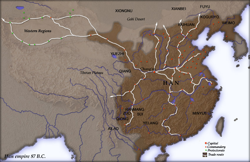
Map of en:Han Dynasty empire 87 BC, showing the capital en:Chang'an and the location of all en:commandery seats. In the Western Regions, a number of pretectorates were Han vassals and under the nominal authority of the Chief Protector of the Western Regions appointed by the Han court. The northern border is the line of the en:Qin Dynasty en:Great Wall. Trade routes are generally based on the work of en:Joseph Needham. Selected non-Chinese peoples are also shown. Created and copyright (2004) by Yuninjie. Released under the GNU FDL. |
|---|---|
| Source | No source specified. Please edit this image description and provide a source. |
| Date | |
| Author |
User Yuninjie on en.wikipedia |
| Permission (Reusing this image) |
Released under the GNU Free Documentation License. |
| Other versions |
Originally from en.wikipedia; description page is (was) here * 00:02, 6 November 2004 [[:en:User:Yuninjie|Yuninjie]] 850×550 (154,737 bytes) <span class="comment">(Map of Han empire 87 BC)</span> |

(Uploaded using CommonsHelper or PushForCommons)
This image was (or all images in this article or category were) uploaded in the JPEG format.
However, it contains information that could be stored more efficiently or more accurately in the PNG format or SVG format. If possible, please upload a PNG or SVG version of this image without compression artifacts, derived from a non-JPEG source or with existing artifacts removed. After doing so, please:
- Find all pages in all Wikimedia projects that use this image, and replace the old image with the new image in each.
- Mark this image as having been superseded by adding one of these templates.
Deutsch | English | Español | Français | 日本語 | Português | Русский | +/-
File history
Click on a date/time to view the file as it appeared at that time.
| Date/Time | Dimensions | User | Comment | |
|---|---|---|---|---|
| current | 09:16, 2 November 2006 | 850×550 (151 KB) | Shizhao | ({{Information| |Description= Map of en:Han Dynasty empire 87 BC, showing the capital en:Chang'an and the location of all en:commandery seats. In the Western Regions, a number of pretectorates were Han vassals and under the nominal authority) |
File links
Metadata
This file contains additional information, probably added from the digital camera or scanner used to create or digitize it. If the file has been modified from its original state, some details may not fully reflect the modified file.
| Orientation | Normal |
|---|---|
| Horizontal resolution | 150 dpi |
| Vertical resolution | 150 dpi |
| Software used | Adobe Photoshop 7.0 |
| File change date and time | 11:03, 6 November 2004 |
| Color space | 65535 |

