Image:Grafschaft Mark 1791 Friedrich C Mueller.jpg
From Wikipedia, the free encyclopedia
Size of this preview: 677 × 599 pixels
Full resolution (2,033 × 1,800 pixels, file size: 1.32 MB, MIME type: image/jpeg)
| | This is a file from the Wikimedia Commons. The description on its description page there is shown below.
|
|
|
This file was a candidate on Picture of the Year 2007. This is a featured picture on Wikimedia Commons: it is considered one of our finest images. If you have an image of similar quality that can be published under a suitable copyright license, be sure to upload it, tag it, and nominate it. |
| This image was selected as a picture of the day for June 22, 2007. It was captioned as followed:
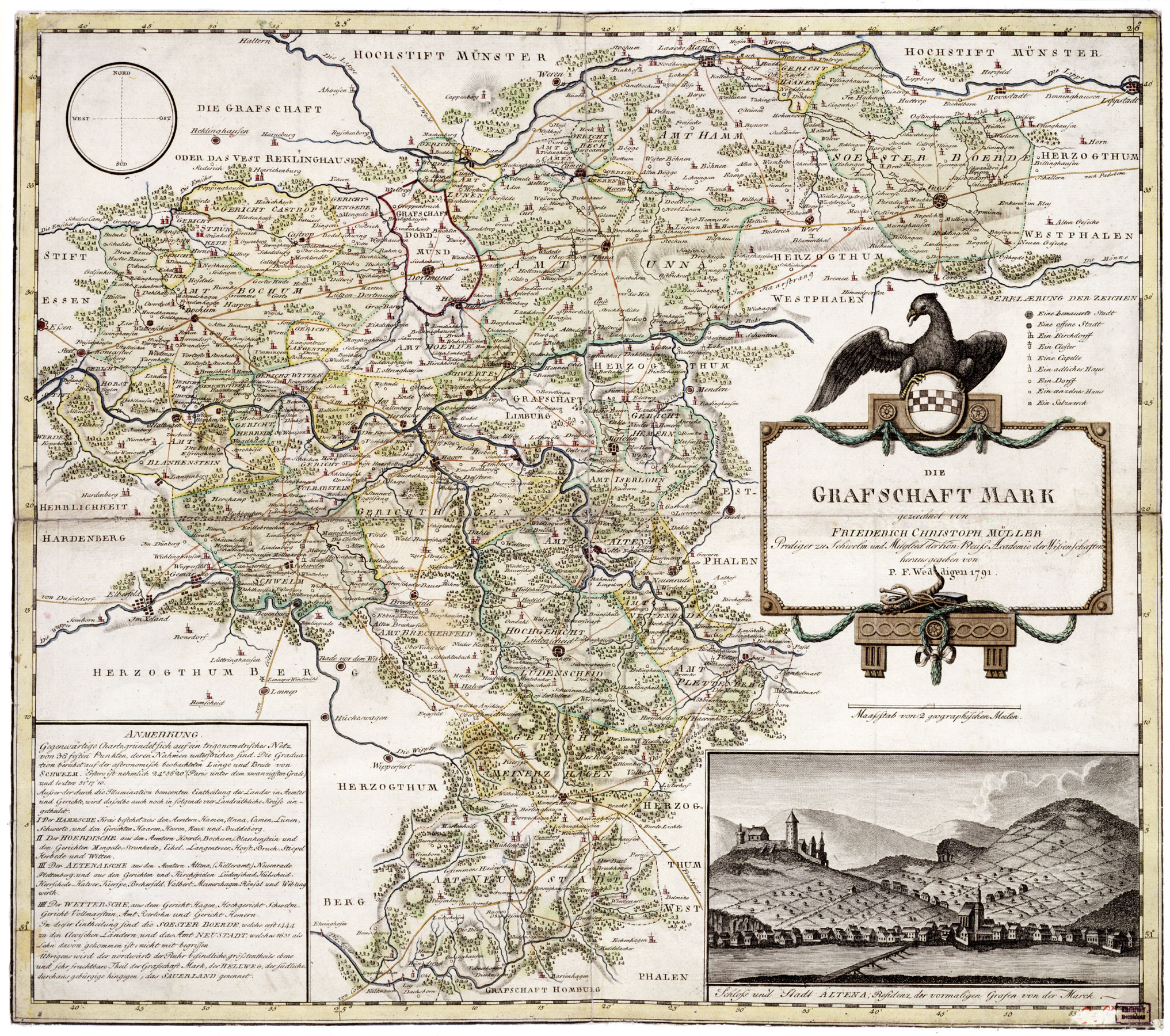
English: Map of County of Mark, Germany, 1791, by Friederich Christoph Müller.
العربية: خريطة لمقاطعة مارك في ألمانيا في عام 1791 وضعها فريدريك كريستوف مولر.
Беларуская: Карта графства Марка, былой краіны ў Свяшчэннай Рымскай імперыі (Фрыдрых Крыстаф Мюлер, 1791)
Česky: Mapa zaniklého německého státu Marka Grafschaft Mark z roku 1791 od Friedricha Christopha Müllera.
English: Map of County of Mark, Germany, 1791, by Friederich Christoph Müller.
Esperanto: Mapo de la graflando de Mark, Germanio (1791), de Friederich Christoph Müller.
Español: Mapa del Condado de Mark, Alemania, 1791, hecho por Friederich Christoph Müller.
Français : Carte du comté de la Marck, 1791, par Friedrich Christoph Müller.
Magyar: A Marki Grófság térképe, Németország, 1791, készítette Friederich Christoph Müller.
Nederlands: Kaart van het Duitse Graafschap Mark (Friederich Christoph Müller, 1791)
Polski: Mapa hrabstwa Mark, Rzesza Niemiecka (1791). Wykonana przez Friedericha Christopha Müllera
Română: Harta comitatului Mark, Germania, 1791, de Friederich Christoph Müller.
Русский: Карта графства Марк, Германия (Фридрих Христоф Мюллер, 1791)
Slovenčina: Mapa nemeckého panstva Grafschaft Mark z roku 1791 od Friedricha Christopha Müllera.
Svenska: Karta över grevskapet Mark i nuvarande Tyskland, ritad av Friederich Christoph Müller, 1791.
中文(简体): 1791年绘制的德国马克县地图。
中文(繁體): 弗里德里希·克里斯托夫·穆勒在1791年繪製的馬克伯爵領地地圖
|
Map of Grafschaft Mark (County of Mark), Germany, 1791, by Friedrich Christoph Müller, Public Domain
Source: http://www.lwl.org/westfaelische-geschichte/
| This image (or other media file) is in the public domain because its copyright has expired. This applies to the United States, Canada, the European Union and those countries with a copyright term of life of the author plus 70 years.
العربية | Asturianu | Български | Català | Česky | Dansk | Deutsch | English | Ελληνικά | Esperanto | Español | Euskara | فارسی | Français | Gaeilge | Galego | עברית | हिन्दी | Bahasa Indonesia | Italiano | 日本語 | 한국어 | Kurdî / كوردی | Lietuvių | Magyar | Nederlands | Norsk (nynorsk) | Bahasa Melayu | Polski | Português | Română | Русский | Slovenčina | Slovenščina | Shqip | Suomi | Sámegiella | Türkçe | 中文(简体) | 中文(繁體) | 粵語 | +/- |
File history
Click on a date/time to view the file as it appeared at that time.
| Date/Time | Dimensions | User | Comment | |
|---|---|---|---|---|
| current | 22:01, 8 January 2007 | 2,033×1,800 (1.32 MB) | Simplicius | (Map of Grafschaft Mark, Germany, 1791, by Friederich Christoph Müller, Public Domain {{PD-old}} Category:1791) |

