Image:Germany sorbian region.png
From Wikipedia, the free encyclopedia
No higher resolution available.
Germany_sorbian_region.png (188 × 235 pixels, file size: 3 KB, MIME type: image/png)
| | This is a file from the Wikimedia Commons. The description on its description page there is shown below.
|
[edit] Description
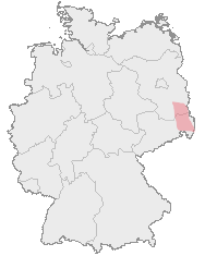
| Description |
Deutsch: Karte von Deutschland mit den Grenzen der Bundesländer und dem ungefähren Verbreitungegebiet der Sorben rot markiert.
Hornjoserbsce: Korta z čerwjenje markěrowanym sydlenskim rumom Serbow.
English: Map of Germany with borders of its federal states and the red marked region where the Sorbs are living.
|
|---|---|
| Source |
Map drawn by User:Dabbelju on basis of Maps generated with http://www.opengeodb.de. |
| Date | |
| Author | |
| Permission (Reusing this image) |
GFDL |
[edit] License

File history
Click on a date/time to view the file as it appeared at that time.
| Date/Time | Dimensions | User | Comment | |
|---|---|---|---|---|
| current | 20:10, 29 August 2007 | 188×235 (3 KB) | 32X | (updated by using Image:Karte Deutschland.png, added transparency) |
| 21:16, 15 November 2005 | 188×235 (5 KB) | Dabbelju | (==Description== {{deutsch}} Karte von Deutschland mit den Grenzen der Bundesländer und dem rot markierten Lebensraum der Sorben. {{english}} Map of Germany with borders of its federal states and the red marked region where the [[:en:Sorbs) |
File links
The following pages on the English Wikipedia link to this file (pages on other projects are not listed):

