Geography of Argentina
From Wikipedia, the free encyclopedia
|
|
||
| Continent | South America | |
| Subregion | Southern Cone | |
| Geographic coordinates | ||
| Area - Total - Water |
Ranked 8th 2,766,890 km² 30,200 km² (1.09%) |
|
| Coastline | 4,989 km | |
| Land boundaries | 9,861 km | |
| Countries bordered | Chile 5,308 km Paraguay 1,880 km Brazil 1,261 km Bolivia 832 km Uruguay 580 km |
|
| Highest point | Cerro Aconcagua, 6,960 m | |
| Lowest point | Laguna del Carbón, -105 m | |
| Longest river | Parana River, 4,700 km | |
| Largest inland body of water | Lake Buenos Aires 1,850 km² | |
| Land Use - Arable land - Permanent crops - Other |
10.03 % 0.36 % 89.61 % (2005 est.) |
|
| Irrigated Land | 15,500km² | |
| Climate: | Temperate to arid to subantarctic | |
| Terrain: | plains, plateau, mountains | |
| Natural resources | fertile plains, lead, zinc, tin, copper, iron ore, manganese, petroleum, uranium | |
| Natural hazards | earthquakes, windstorms, heavy flooding | |
| Environmental issues | deforestation, soil degradation, desertification, air and water pollution | |
| Argentina by subject |
|---|
|
Communications |
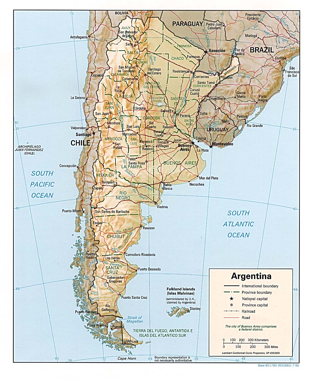
Argentina is a country in southern South America, situated between the Andes in the west and the southern Atlantic Ocean in the east. It is bordered by Paraguay and Bolivia in the north, Brazil and Uruguay in the northeast and Chile in the west.
Argentina is the second largest country of South America after Brazil and the 8th largest country in the world. Its total area is approximately 2.7 million km². Argentina claims a section of Antarctica (Argentine Antarctica) but has agreed to suspend sovereignty disputes in the region as a signatory to the Antarctic Treaty. Argentina also asserts claims to several South Atlantic islands administered by the United Kingdom.
Contents |
[edit] Geographical zones
| Regions of |
|---|
| Argentine Northwest |
| Gran Chaco |
| Mesopotamia |
| Cuyo |
| Pampas |
| Patagonia |
| Antártida Argentina |
The country's provinces are divided in 6 zones regarding climate and terrain. From North to South, West to East:
- Argentine Northwest: Jujuy, Salta, Tucumán, Catamarca, La Rioja
- Gran Chaco: Formosa, Chaco, Santiago del Estero
- Mesopotamia: Misiones, Entre Ríos, Corrientes
- Cuyo: San Juan, Mendoza, San Luis
- The Pampas: Córdoba, Santa Fe, La Pampa, Buenos Aires
- Patagonia: Rio Negro, Neuquén, Chubut, Santa Cruz, Tierra del Fuego
[edit] Climate
[edit] Land use
- Arable land:9%
- Permanent crops: 1%
- Permanent pastures: 52%
- Forests and woodland: 19%
- Other: 19% (1993 est.)
- Irrigated land: 17,000 km² (1993 est.)
[edit] Rivers and Lakes
Major rivers in Argentina include the Pilcomayo, Paraguay, Bermejo, Colorado, Río Negro, Salado, Uruguay and the largest river, the Paraná. The latter two flow together before meeting the Atlantic Ocean, forming the estuary of the Río de la Plata. Regionally important rivers are the Atuel and Mendoza in the homonymous province, the Chubut in Patagonia, the Río Grande in Jujuy, and the San Francisco River in Salta.
There are several large lakes in Argentina, many of them in Patagonia. Among these are lakes Argentino and Viedma in Santa Cruz, Nahuel Huapi in Río Negro and Fagnano in Tierra del Fuego, and Colhué Huapi and Musters in Chubut. Lake Buenos Aires and O'Higgins/San Martín Lake are shared with Chile. Mar Chiquita, Córdoba, is the largest salt water lake in the country. There are numerous reservoirs created by dams. Argentina features various hot springs, such as those at Termas de Río Hondo with temperatures between 30°C and 65°C.
[edit] Environment
Current issues: Environmental problems (urban and rural) typical of an industrialising economy such as soil degradation, desertification, air pollution, and water pollution. Argentina is a world leader in setting voluntary greenhouse gas targets.
Natural hazards:
- San Miguel de Tucumán and Mendoza areas in the Andes subject to earthquakes
- Pamperos are violent windstorms that can strike the Pampas and northeast
- Heavy flooding in the Mesopotamia
[edit] Geographical Politics
International agreements:
- Party to: Antarctic Treaty, Antarctic-Environmental Protocol, Biodiversity, Climate Change, Desertification, Endangered Species, Environmental Modification, Hazardous Wastes, Law of the Sea, Marine Dumping, Nuclear Test Ban, Ozone Layer Protection, Ship Pollution, Wetlands, Whaling
- Signed, but not ratified: Climate Change-Kyoto Protocol, Marine Life Conservation
Strategic importance:
- Location relative to sea lanes between South Atlantic and South Pacific Oceans (Strait of Magellan, Beagle Channel, Drake Passage)
[edit] See also
- List of islands of Argentina
- List of mountains in Argentina
- List of regions in Argentina
- Protected areas of Argentina
- List of rivers of Argentina
[edit] References
- This article contains material from the CIA World Factbook which, as a U.S. government publication, is in the public domain.
- This article contains material from the US Department of State's Background Notes which, as a US government publication, is in the public domain.
- UT Perry Castenada Map - Argentina Map Website Map
|
||||||||||||||

