Image:GeneralMapOfDistancesAndHistoricCapitals.jpg
From Wikipedia, the free encyclopedia
Size of this preview: 744 × 599 pixels
Full resolution (3,493 × 2,814 pixels, file size: 6.14 MB, MIME type: image/jpeg)
| | This is a file from the Wikimedia Commons. The description on its description page there is shown below.
|
[edit] Summary
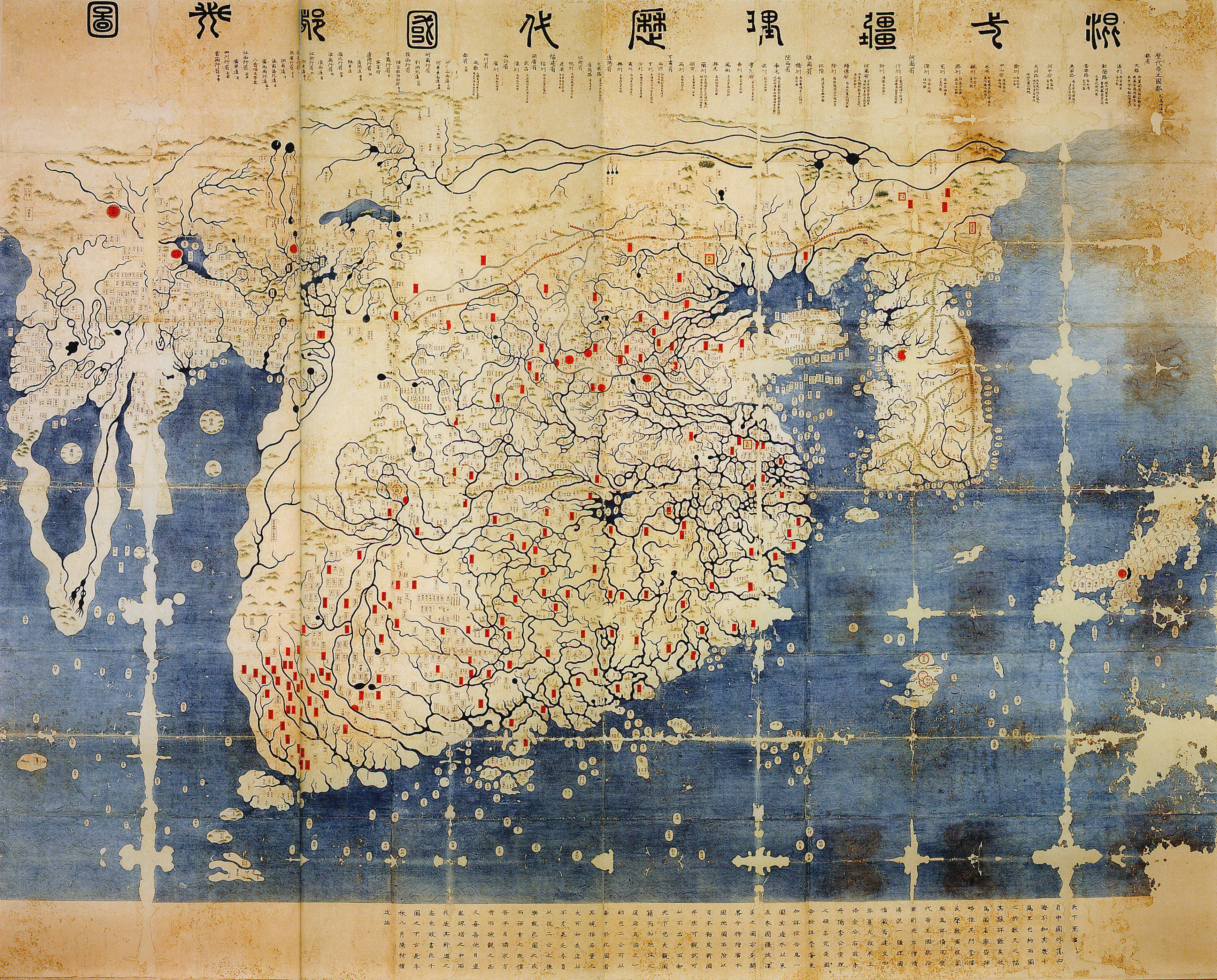
| Description |
General map of the distances and the historic capitals (chinese: Hunyi jiangli lidai guodu zhi tu; japanese: Kon'itsu kyoori rekidai kokuto no zu), Korea, roughly 1470. Ink and paint on paper. Height 220 cm, width 289 cm. Honkoo-ji Tokiwa Museum of Historical Materials, Shimabara, Nagasaki prefecture. Based on two Chinese maps from the 14th century, Shengjiao guangbei tu (Big map that shows the pronounciation of place names) and Hunyi jiangli tu (General map of the distances also showing historical capitals [of China]). Both maps were brought to Korea in 1368, and put together to one new map around 1402. The most obvious feature distinguishing this later version from the original Kangnido is the more correct size and orientation of Japan. The geographical knowledge represented in the map beyond China and Korea seems mainly a result of 14th century trade connections within the Mongol Empire. On the western edge of the map the names Marseille and Sevilla have been identified. Note the depiction of the Cape of Good Hope, the second-earliest known to date. Note: The "crack" on the left side of the image is due to the map being printed on two adjacent pages in the source, an exhibition catalogue. It is not from the original (just in case someone might wonder). |
|---|---|
| Source |
Dschingis Khan und seine Erben (exhibition catalogue), München 2005, p. 336/7 |
| Date |
roughly 1470 |
| Author |
unknown / (of the reproduction) Honkoo-ji Tokiwa Museum of Historical Materials, Shimabara, Nagasaki prefecture |
| Permission (Reusing this image) |
see below |
[edit] Licensing
This photographic reproduction is therefore also in the public domain. العربية | Česky | Deutsch | English | Ελληνικά | Español | فارسی | Français | עברית | Bahasa Indonesia | Italiano | 日本語 | 한국어 | Magyar | Nederlands | Polski | Português | Română | Русский | Slovenščina | Српски / Srpski | Basa Sunda | Türkçe | Українська | 中文(繁體) | 中文(简体) | +/- |
File history
Click on a date/time to view the file as it appeared at that time.
| Date/Time | Dimensions | User | Comment | |
|---|---|---|---|---|
| current | 14:40, 11 June 2008 | 3,493×2,814 (6.14 MB) | Yaan | (== Summary == {{Information |Description = General map of the distances and the historic capitals (chinese: Hunyi jiangli lidai guodu zhi tu; japanese: Kon'itsu kyoori rekidai kokuto no zu), Korea, roughly 1470. Ink and paint on paper. Height 220 cm, widt) |

