Image:Gedrosia-Map-Route-of-Alexander-1823-Lucas.png
From Wikipedia, the free encyclopedia
Size of this preview: 596 × 600 pixels
Full resolution (656 × 660 pixels, file size: 881 KB, MIME type: image/png)
| | This is a file from the Wikimedia Commons. The description on its description page there is shown below.
|
[edit] Summary
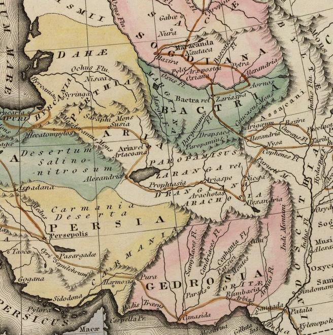
| Description |
Map of the route of Alexander the Great through Gedrosia, Bactria, and Sogdiana part of a map entitled "Alexandri Magni Itinera" based upon Melish (1815) Atlas of Ancient Geography |
|---|---|
| Source |
scanned from Plate 12 of A general atlas containing distinct maps of all the known countries in the world by Fielding Lucas |
| Date |
1823 |
| Author |
engraved by J. Yeager, published by Fielding Lucas |
| Permission (Reusing this image) |
Public Domain |
[edit] Licensing
This photographic reproduction is therefore also in the public domain. العربية | Česky | Deutsch | English | Ελληνικά | Español | فارسی | Français | עברית | Bahasa Indonesia | Italiano | 日本語 | 한국어 | Magyar | Nederlands | Polski | Português | Română | Русский | Slovenščina | Српски / Srpski | Basa Sunda | Türkçe | Українська | 中文(繁體) | 中文(简体) | +/- |
File history
Click on a date/time to view the file as it appeared at that time.
| Date/Time | Dimensions | User | Comment | |
|---|---|---|---|---|
| current | 17:51, 29 November 2007 | 656×660 (881 KB) | Bejnar | ({{Information |Description=Map of the route of Alexander the Great through Gedrosia, Bactria, and Sogdiana part of a map entitled "Alexandri Magni Itinera" based upon Melish (1815) ''Atlas of Ancient Geography'' |Source= scanned from Plate 12 of ''A gener) |

