Image:GD-EG-Deir el Bahari-map.png
From Wikipedia, the free encyclopedia
No higher resolution available.
GD-EG-Deir_el_Bahari-map.png (443 × 599 pixels, file size: 104 KB, MIME type: image/png)
| | This is a file from the Wikimedia Commons. The description on its description page there is shown below.
|
[edit] Description
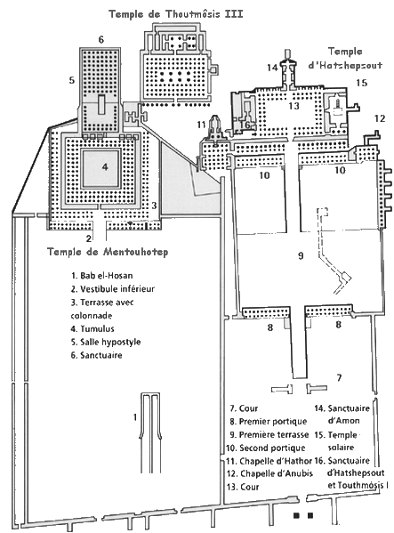
Español: Deir el-Bahari: mapa de los tres templos
Français :
Plan du site de Deir el Bahari (Égypte).
[edit] Licence
| This file is licensed under the Creative Commons Attribution ShareAlike 2.5 License. In short: you are free to share and make derivative works of the file under the conditions that you appropriately attribute it, and that you distribute it only under a license identical to this one. Official license |
[edit] Source
Français :
Dessin de Gérard Ducher (user:Néfermaât).
English:
Drawing by Gérard Ducher
File history
Click on a date/time to view the file as it appeared at that time.
| Date/Time | Dimensions | User | Comment | |
|---|---|---|---|---|
| current | 08:30, 30 September 2006 | 443×599 (104 KB) | Janmad | (More light) |
| 22:12, 13 January 2006 | 446×603 (245 KB) | Néfermaât | (== Description == fr: Plan du site de Deir el Bahari Égypte. ==Source== fr: Dessin de Gérard Ducher (user:Néfermaât). Nefermaat == Licence == {{cc-by-sa-2.5}} ) |
File links
The following pages on the English Wikipedia link to this file (pages on other projects are not listed):

