Image:FuehrerBunkerBerlinLocation.jpg
From Wikipedia, the free encyclopedia
Size of this preview: 506 × 600 pixels
Full resolution (700 × 830 pixels, file size: 532 KB, MIME type: image/jpeg)
| | This is a file from the Wikimedia Commons. The description on its description page there is shown below.
|
| Description |
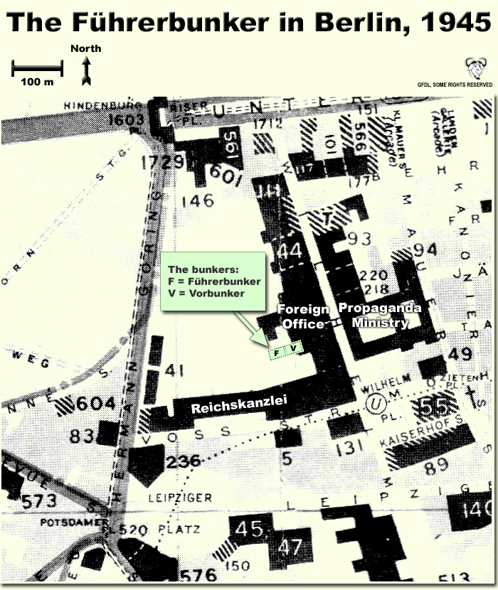
Map showing the locations of the Fuehrerbunker and Vorbunker in Berlin, 1945. |
|---|---|
| Source |
Self-made |
| Date |
October 12, 2007 |
| Author | |
| Permission (Reusing this image) |
CC, see below. The map is completely unrestricted for any Wikipedia/Wikimedia project. |
| Other versions | None |
Contents |
[edit] Licensing
|
[edit] Description
This is a map showing the locations of the Fuehrerbunker and Vorbunker in Berlin, 1945. These locations are not necessarily perfectly exact, but they are very probable. There were two bunkers which were connected - the Fuehrerbunker and the Vorbunker, and here are the links to my maps of these bunkers:
Information about the details of the bunkers is rather scarce, which is not strange, since the bunkers were secret. This map is based on the excellent research of Tom Posch (see below), who visited and photographed the remains from inside in 1988. He concluded that the map of the bunker in Cornelius Ryan's The Last Battle was incorrect, and a new, hand-drawn map of the Vorbunker was produced by Tom Posch.
[edit] Notes on the location of the bunkers
The Fuehrerbunker, built in 1944, was located 8-17 meters beneath the Reichskanzlei garden, approx. 120 meters north of the new Reichskanzlei building, which had the address Vossstrasse 6. The Führerbunker was located somewhat lower than the Vorbunker and west (or rather west-west-south) of it. The two bunkers were connected via sets of stairs set at right angles (not spiral).
[edit] Construction data (approximates)
- Material: Concrete
- Protective Wall Width: 220 cm
- Protective Roof Height: 280 cm
- Wall Width (interior): 15-20 cm
- Door Heights: 180-200 cm
- Door Widths: 120 cm
- Room Heights: 2-3 m
- Room Sizes: Varying; 3-5 m
[edit] References
The map is based on the following sources:
- Ramsey, Winston G. (editor) & Posch, Tom (researcher), The Berlin Führerbunker: The Thirteenth Hole, After the Battle, No.61, Special Edition, Battle of Britain International Ltd, 1988, London
- Allied Intelligence Map of Key Buildings in Berlin (3rd edition, 1945)
- Ryan, Cornelius, The Last Battle (1966)
Regards, Dennis Nilsson, Sweden.
If you wish to contact me, please leave a message on my talk page.
File history
Click on a date/time to view the file as it appeared at that time.
| Date/Time | Dimensions | User | Comment | |
|---|---|---|---|---|
| current | 02:37, 12 October 2007 | 700×830 (532 KB) | Dna-webmaster | (minor fix) |
| 02:06, 12 October 2007 | 700×830 (530 KB) | Dna-webmaster | (Uploaded new version) | |
| 00:19, 14 December 2005 | 720×946 (442 KB) | Dna-webmaster | ||
| 08:30, 14 November 2005 | 720×946 (453 KB) | Dna-webmaster |
File links
Metadata
This file contains additional information, probably added from the digital camera or scanner used to create or digitize it. If the file has been modified from its original state, some details may not fully reflect the modified file.
| Orientation | Normal |
|---|---|
| Horizontal resolution | 200 dpi |
| Vertical resolution | 200 dpi |
| Software used | Adobe Photoshop 7.0 |
| File change date and time | 04:45, 12 October 2007 |
| Color space | 65535 |

