Image:Free Territory of Trieste map.png
From Wikipedia, the free encyclopedia
Size of this preview: 381 × 599 pixels
Full resolution (511 × 804 pixels, file size: 108 KB, MIME type: image/png)
| | This is a file from the Wikimedia Commons. The description on its description page there is shown below.
|
[edit] Summary
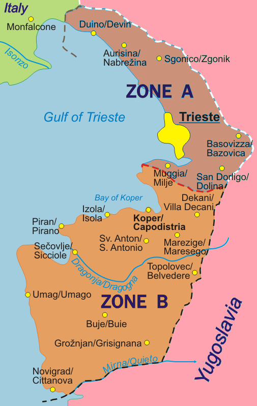
Map of the Free Territory of Trieste (1947-1954), with zone delimitation, in English. Own adaptation of http://sl.wikipedia.org/wiki/Slika:STO.png from the Slovene Wikipedia, by kind permission of the original author.
German version: Image:Freies_Territorium_Triest_Karte.png
Italian version: Image:Territorio_libero_di_Trieste_carta.png
[edit] Licensing
| I, the copyright holder of this work, hereby release it into the public domain. This applies worldwide. In case this is not legally possible: Afrikaans | Alemannisch | Aragonés | العربية | Asturianu | Български | Català | Česky | Cymraeg | Dansk | Deutsch | Eʋegbe | Ελληνικά | English | Español | Esperanto | Euskara | Estremeñu | فارسی | Français | Galego | 한국어 | हिन्दी | Hrvatski | Ido | Bahasa Indonesia | Íslenska | Italiano | עברית | Kurdî / كوردی | Latina | Lietuvių | Latviešu | Magyar | Македонски | Bahasa Melayu | Nederlands | Norsk (bokmål) | Norsk (nynorsk) | 日本語 | Polski | Português | Ripoarisch | Română | Русский | Shqip | Slovenčina | Slovenščina | Српски / Srpski | Svenska | ไทย | Tagalog | Türkçe | Українська | Tiếng Việt | Walon | 中文(简体) | 中文(繁體) | zh-yue-hant | +/- |
File history
Click on a date/time to view the file as it appeared at that time.
| Date/Time | Dimensions | User | Comment | |
|---|---|---|---|---|
| current | 01:32, 6 October 2007 | 511×804 (108 KB) | Tomchiukc | (replace colours of map to distinguish land from the sea.) |
| 16:36, 6 October 2005 | 511×804 (122 KB) | Alib | (Map of the Free Territory of Trieste (1947-1954), with zone delimitation, in English. Own adaptation of http://sl.wikipedia.org/wiki/Slika:STO.png from the Slovene Wikipedia, by kind permission of the original author. German version: [[Freies_Territorium_) |

