Image:France radar 2.jpg
From Wikipedia, the free encyclopedia
Size of this preview: 628 × 600 pixels
Full resolution (2,172 × 2,074 pixels, file size: 3.13 MB, MIME type: image/jpeg)
| | This is a file from the Wikimedia Commons. The description on its description page there is shown below.
|
[edit] Summary
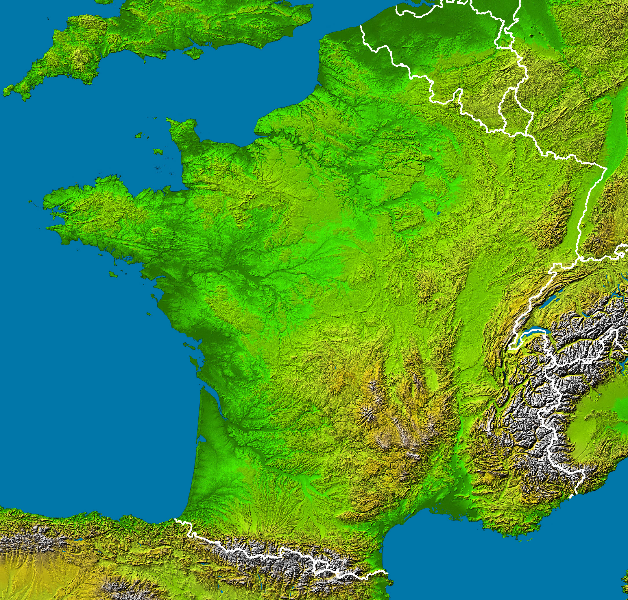
en :
- Subject : France viewed by NASA Shuttle radar-imaging ;
- Source : NASA Earth Observatory (modified) ;
- Original image in Wikipedia : Image:France_radar.jpg ;
- This version : Without shadows along the borders, modified by Sting.
fr :
- Sujet : Image radar de la France vue depuis la navette spatiale, par la NASA ;
- Source : NASA Earth Observatory (modifiée) ;
- Image originale sur Wikipédia : Image:France_radar.jpg ;
- Cette version : Sans ombres le long des frontières, modifiée par Sting.
English: This map was made or improved by the Wikigraphists of the Atelier graphique. You can propose maps or images to clean up and improve as well.
Esperanto: Ĉi tiu mapo estis kreita aŭ plibonigita de la Vikigrafistoj el la Grafika laborgrupo. Vi ankaŭ povas tie proponi mapojn aŭ bildojn plibonigendajn.
Español: Este mapa ha sido confeccionado o mejorado por los Wikígrafos del Taller gráfico. Puedes proponer la mejora de cualquier imagen a través de la página de Peticiones.
Français : Cette carte a été créée ou améliorée par les Wikigraphistes de l'Atelier graphique. Vous pouvez également y proposer des cartes ou des images à améliorer.
Türkçe: Bu harita Atelier graphique'ten Wikigraphistes'ler tarafından yapıldı veya geliştirildi. Siz de haritalar veya resimleri temizlemek veya geliştirmek için teklif edebilirsiniz.
[edit] Licensing
- The purpose of NASA's Earth Observatory is to provide a freely-accessible publication on the Internet where the public can obtain new satellite imagery and scientific information about our home planet. The focus is on Earth's climate and environmental change. In particular, we hope our site is useful to public media and educators. Any and all materials published on the Earth Observatory are freely available for re-publication or re-use, except where copyright is indicated. We ask that NASA's Earth Observatory be given credit for its original materials.
|
|
This file is in the public domain because it was created by NASA. NASA copyright policy states that "NASA material is not protected by copyright unless noted". (NASA copyright policy page or JPL Image Use Policy).
Deutsch | English | Español | Français | Nederlands | Português | Русский | 中文(简体) | 中文(繁體) | +/- |
|
 |
Warnings:
|
| This work was previously under Public Domain, or a Free License. It has been digitally enhanced and/or modified. This derivative work has been (or is hereby) released into the public domain by its author, Sting at the French Wikipedia project. This applies worldwide. In some countries this is not legally possible; if so: |
File history
Click on a date/time to view the file as it appeared at that time.
| Date/Time | Dimensions | User | Comment | |
|---|---|---|---|---|
| current | 04:23, 23 February 2006 | 2,172×2,074 (3.13 MB) | Sting | ('''en :''' * '''Subject :''' France viewed by NASA Shuttle radar-imaging ; * '''Source :''' [http://earthobservatory.nasa.gov/Newsroom/NewImages/images.php3?img_id=15360 NASA Earth Observatory] (modified) ; * '''Original image in Wikipedia :''' [[:Image:) |
File links
The following pages on the English Wikipedia link to this file (pages on other projects are not listed):
Metadata
This file contains additional information, probably added from the digital camera or scanner used to create or digitize it. If the file has been modified from its original state, some details may not fully reflect the modified file.
| Image title | converted PNM file |
|---|---|
| Orientation | Normal |
| Horizontal resolution | 18 dpi |
| Vertical resolution | 18 dpi |
| Software used | Adobe Photoshop 7.0 |
| File change date and time | 02:04, 23 February 2006 |
| Color space | 65535 |

