Image:First of June 1794 Map.png
From Wikipedia, the free encyclopedia
No higher resolution available.
First_of_June_1794_Map.png (431 × 522 pixels, file size: 12 KB, MIME type: image/png)
| | This is a file from the Wikimedia Commons. The description on its description page there is shown below.
|
[edit] Summary
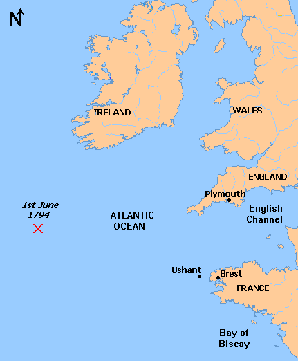
| Description |
Map of the location of the naval battle on June 1, 1794 between the British Royal Navy and the French Navy |
|---|---|
| Source |
self-made, from Image:Mappa an Mor Keltek.png by QuartierLatin1968 who made this file from a public domain original, generated at OMC. Source of battle location is the book "Revolution and Political Conflict in the French Navy, 1789-1794" by William S. Cormack, here |
| Date |
Febraury 2008 |
| Author | |
| Permission (Reusing this image) |
Original is PD, my modifications are GFDL |
| Other versions | Image:Mappa an Mor Keltek.png |
[edit] Licensing

File history
Click on a date/time to view the file as it appeared at that time.
| Date/Time | Dimensions | User | Comment | |
|---|---|---|---|---|
| current | 00:43, 11 February 2008 | 431×522 (12 KB) | Ruhrfisch | (Fix spelling error, all other information is the same) |
| 00:10, 11 February 2008 | 431×522 (12 KB) | Ruhrfisch | (== Summary == {{Information |Description= Map of the location of the naval battle on June 1, 1794 between the British Royal Navy and the French Navy |Source=self-made, from Image:Mappa an Mor Keltek.png by [[User:QuartierLatin1968|QuartierLatin1968]) |
File links
The following pages on the English Wikipedia link to this file (pages on other projects are not listed):

