Image:Farquhar atoll.jpg
From Wikipedia, the free encyclopedia
No higher resolution available.
Farquhar_atoll.jpg (407 × 431 pixels, file size: 38 KB, MIME type: image/jpeg)
| | This is a file from the Wikimedia Commons. The description on its description page there is shown below.
|
[edit] Information
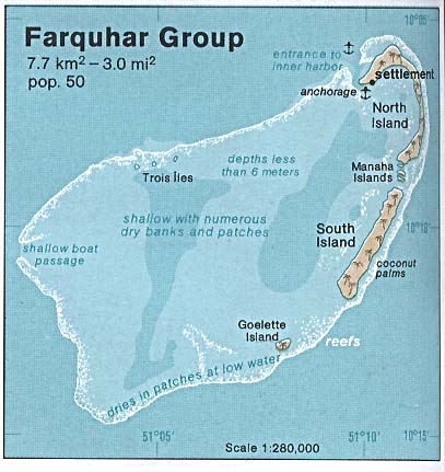
| Description |
Deutsch: Karte des Farquhar-Atolls, Seychellen
English: Map of Farquhar Atoll, Outer Islands of Seychelles
Español: Mapa de Farquhar (Atolón de Farquhar), Archipiélago de Seychelles
|
|---|---|
| Source |
http://www.lib.utexas.edu/maps/islands_oceans_poles/farquhar_group_76.jpg |
| Date |
1976 |
| Author |
Taken from Perry-Castañeda Library (PCL), originally from CIA Indian Ocean Atlas |
| Permission (Reusing this image) |
PD, see licensing |
[edit] Licensing
| This image is a work of a Central Intelligence Agency employee, taken or made during the course of the person's official duties. As a Work of the United States Government, all images created or made by the CIA are in the public domain, with the exception of classified information. |  |
[edit] Original Upload Log
Original Uploader: en:User:SDC at 3 July 2005.
Legend: (cur) = this is the current file, (del) = delete this old version, (rev) = revert to this old version.
- (del) (cur) 15:09, 3 July 2005 . . SDC (Talk | contribs) . . 407×431 (38,797 bytes) (CIA Public Domain)
File history
Click on a date/time to view the file as it appeared at that time.
| Date/Time | Dimensions | User | Comment | |
|---|---|---|---|---|
| current | 12:04, 25 May 2007 | 407×431 (38 KB) | Telim tor | (== Information == {{Information |Description=Map of Farquhar Atoll, Seychelles |Source=http://www.lib.utexas.edu/maps/islands_oceans_poles/farquhar_group_76.jpg |Date=1976 |Author=Taken from Perry-Castañeda Library (PCL), originally from CIA Indian Ocean) |
File links
The following pages on the English Wikipedia link to this file (pages on other projects are not listed):

