Image:Eva-archaic-site-profile-tn1.jpg
From Wikipedia, the free encyclopedia
No higher resolution available.
Eva-archaic-site-profile-tn1.jpg (421 × 234 pixels, file size: 15 KB, MIME type: image/jpeg)
| | This is a file from the Wikimedia Commons. The description on its description page there is shown below.
|
This image was (or all images in this article or category were) uploaded in the JPEG format.
However, it contains information that could be stored more efficiently or more accurately in the PNG format or SVG format. If possible, please upload a PNG or SVG version of this image without compression artifacts, derived from a non-JPEG source or with existing artifacts removed. After doing so, please:
- Find all pages in all Wikimedia projects that use this image, and replace the old image with the new image in each.
- Mark this image as having been superseded by adding one of these templates.
Deutsch | English | Español | Français | 日本語 | Português | Русский | +/-
[edit] Summary
| Description |
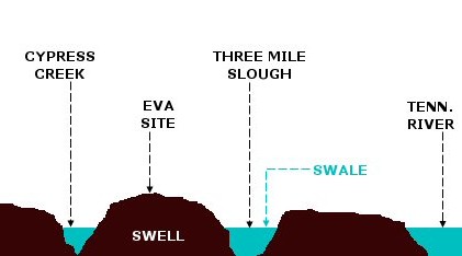
A profile diagram of the floodplain upon which the Eva archaic site was located. Before the completion of Kentucky Dam inundated the site in 1944, the floodplain was characterized by a "swell-and-swale" topography. Swales are ancient river channels and tributary channels that are still filled with water, whereas swells are natural levees created by soil deposits from these ancient streams. The Tennessee River originally flowed through Three Mile Slough. This diagram is based on the description of the site given by Lewis and Lewis: Eva, an Archaic site, 1-4 (1961). NOT drawn to scale. |
|---|---|
| Source |
self-made |
| Date |
3/16/2008 |
| Author | |
| Permission (Reusing this image) |
see below |
[edit] Licensing:

File history
Click on a date/time to view the file as it appeared at that time.
| Date/Time | Dimensions | User | Comment | |
|---|---|---|---|---|
| current | 20:56, 17 March 2008 | 421×234 (15 KB) | Bms4880 | ({{Information |Description=A profile diagram of the floodplain upon which the Eva archaic site was located. Before the completion of Kentucky Dam inundated the site in 1944, the floodplain was characterized by a "swell-and-swale" topography. Swales are ) |

