Image:Europe map Napoleon 1811.png
From Wikipedia, the free encyclopedia
No higher resolution available.
Europe_map_Napoleon_1811.png (415 × 422 pixels, file size: 13 KB, MIME type: image/png)
| | This is a file from the Wikimedia Commons. The description on its description page there is shown below.
|
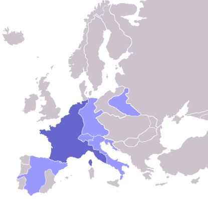
Map of the w:First French Empire and satellite states, with w:1811 borders. Created by User:OwenBlacker from Image:Europe blank map.png, therefore they are the source.

| This file is licensed under Creative Commons Attribution ShareAlike 2.0 England & Wales (UK) Licence |
|
File history
Click on a date/time to view the file as it appeared at that time.
| Date/Time | Dimensions | User | Comment | |
|---|---|---|---|---|
| current | 00:53, 16 October 2006 | 415×422 (13 KB) | Deltabeignet | (Corrected status of Illyrian provinces.) |
| 00:51, 21 August 2005 | 415×422 (11 KB) | OwenBlacker | (Map of the w:First French Empire and satellite states, with w:1811 borders. Created by User:OwenBlacker from Image:Europe blank map.png {{GFDL}} {{cc-by-sa-2.0-uk}}) |
File links
The following pages on the English Wikipedia link to this file (pages on other projects are not listed):
- History of France
- Napoleonic Wars
- Batavian Republic
- Kingdom of Holland
- Napoleon I of France
- Parthenopaean Republic
- Berg (state)
- Valais
- First French Empire
- Grand Duchy of Frankfurt
- Kingdom of Naples
- Vaud
- Cisalpine Republic
- Duchy of Warsaw
- Helvetic Republic
- Confederation of the Rhine
- Roman Republic (18th century)
- Cisrhenian Republic
- Military history of France
- Bishopric of Würzburg
- Ligurian Republic
- Italian Republic (Napoleonic)
- Kingdom of Etruria
- Cispadane Republic
- Kingdom of Italy (Napoleonic)
- Kingdom of Westphalia
- Great French War
- Principality of Leyen
- Transpadane Republic
- Republic of Alba
- Republic of Ancona
- Tiberina Republic
- Bolognese Republic
- French client republic
- Subalpine Republic
- Republic of Mainz
- Republic of Connaught
- Rauracian Republic
- Organic Articles
- Template:Client states of the Great French War
- Republic of Bergamo
- Free City of Danzig (Napoleonic)
- Republic of Bouillon
- User:Ssolbergj/Federal Europe
- Swiss Confederation (Napoleonic)

