Image:Eurabia map.png
From Wikipedia, the free encyclopedia
No higher resolution available.
Eurabia_map.png (323 × 330 pixels, file size: 4 KB, MIME type: image/png)
| | This is a file from the Wikimedia Commons. The description on its description page there is shown below.
|
[edit] Summary
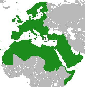
| Description |
"Eurabia" map of combined European Union current & prospective members with Arab League member and observer states. National boundaries erased (because supposed Eurabia conspiracy is transnational,) Israel & Palestinian territories coloured in (because destruction of Israel is integral part of supposed Eurabia conspiracy.) |
|---|---|
| Source |
Derivative of Image:BlankMap-World.png |
| Date |
15 March 2008 |
| Author |
User:Eleland and authors of source image |
| Permission (Reusing this image) |
GFDL |
| Other versions | N/A |
[edit] Licensing:

File history
Click on a date/time to view the file as it appeared at that time.
| Date/Time | Dimensions | User | Comment | |
|---|---|---|---|---|
| current | 19:33, 15 March 2008 | 323×330 (4 KB) | Eleland | ({{Information |Description="Eurabia" map of combined European Union current & prospective members with Arab League member and observer states. National boundaries erased (because supposed Eurabia conspiracy is transnational,) Israel & Palestinian territor) |
File links
The following pages on the English Wikipedia link to this file (pages on other projects are not listed):

